Mammoth Announces Results of Independent Study of the Target for Further Exploration on its Tenoriba, Gold-Silver Property, Mexico Confirming Greater than One Million Ounce Gold Equivalent Target
 | |||||||||
Toronto, Canada – TheNewswire - November 21, 2024 - Mammoth Resources Corp. (TSX-V: MTH), (the “Company”, or “Mammoth”) is pleased to announce the results from an independent study which identified and confirmed Mammoth’s internal study of the gold-silver target for further exploration (“Exploration Target”, “Target”) at Mammoth’s 100% owned Tenoriba exploration property in the Sierra Madre precious metal belt, Mexico.
The independent study, similar to Mammoth’s internal study, was performed under the guidelines of National Instrument 43-101, section 2.3 (2), including the range of the quantity and grade of the Exploration Target within the shallow, near-surface mixed oxidized-sulfide/transition zone mineralized horizon at Tenoriba. The study was performed by Edgardo Espinosa Velasco (“Velasco study”). Richard Simpson, Mammoth’s Qualified-Competent Person summarized the work performed by Mr. Valesco in a report, including the methodology, calculated results, conclusions and recommendations from this work. The report is available on Mammoth’s website; Projects section, under Technical Reports, and describes the basis upon which this Exploration Target has been determined. It should be noted that in accordance with NI 43-101 this Target is conceptual in nature and therefore it is uncertain whether further exploration will result in this Target being delineated.
The following table illustrates a comparison of the range of the Exploration Target in the two studies, within the mixed oxidized-sulfide/transition zone mineralized horizon.

Thomas Atkins, President and CEO of Mammoth Resources commented on the Valesco exploration target study, stating: “It’s interesting and a welcome confirmation to see an independent study arrive at a similar target for further exploration to that which Mammoth determined from its own study of this target. This independently studied target similarly exceeds a million ounces of gold equivalent mineralization in the shallow to near-surface, oxidized-sulfide/transition zone mineralized horizon at Tenoriba.
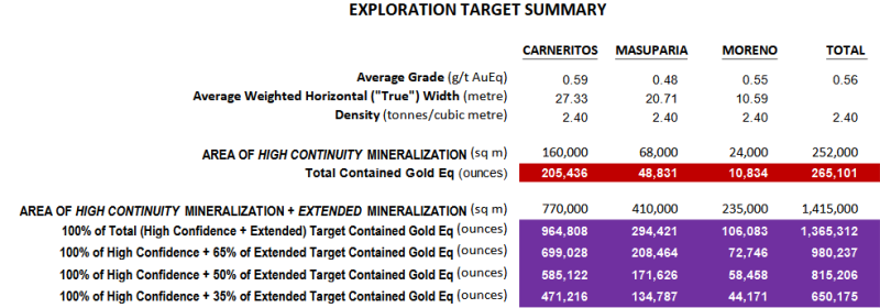
“Of particular interest in the Valesco study was that Mr. Valesco considered what he defined as a High Confidence area of mineral potential which was determined by a 40-metre radius from the collar of historical drill holes with intervals equal to or greater than what was designated a cut-off grade of 0.18 grams per tonne gold equivalent. This cut-off grade yielded an average grade of 0.56 grams per tonne gold equivalent for a total of 265,101 gold equivalent ounces in this High Confidence area. Although not calculated to NI 43-101 standards for a mineral resource, this 40-metre radius is the same distance from drill hole collars as was suggested in an independent study of the drill hole spacing required at Tenoriba to identify an initial mineral resource at Tenoriba. That the Valesco study determined this High Confidence target based only on the current 55 holes drilled at Tenoriba, we believe bodes well for the resource potential that could be defined at Tenoriba as Mammoth moves towards additional drilling to define a mineral resource.
“I’m very pleased with what this study illustrates. We always suspected there was a sizable exploration target at Tenoriba given how frequently we’ve sampled and drilled tens of metres of gold-silver mineralization throughout the six-kilometre trend of gold-silver mineralization at Tenoriba.
“Mammoth is looking forward to advancing towards drill testing this target and defining a NI 43-101 mineral resource at Tenoriba.”
Richard Simpson, Vice President Exploration of Mammoth Resources further commented on the Exploration Target, stating: “Mammoth recently obtained quotes from Mexican drill contractors, the most competitive of which confirmed an all-inclusive cost of US$272/metre. Phase One of Mammoth’s planned resource definition drilling program is focused on the large Carneritos area and consists of 60 drill holes to depths of approximately 50 m for a total of 3,000 m drilling. With targets ranging from 817,499 to 964,808 ounces gold equivalent in the Mammoth and Valesco studies, respectively, the quoted drill costs suggest as little as US$800,000 to define the initial Phase One mixed oxidized-sulfide/transition zone mineralized target resource, or a cost of US$1.50 per gold equivalent ounce.”
“We believe there’s excellent potential to define a sizeable mineral resource in low-cost, near-surface drilling of the mixed oxidized-sulfide/transition horizon at Tenoriba, especially in our initial phase drilling at Carneritos where the greatest of this potential exists. This target drilling offers enormous leverage to success. Beyond the near-surface target, there exists an additional near one million ounce target in the lower sulfide horizon offering further leverage to success.”
Reliance on Information, Methodology for Determining the Exploration Target and Recommendations:
The Valesco Exploration Target study relied on thousands of gold-silver sample analyses from 55 diamond drill holes and a Google Earth image to interpret favourable surface geomorphology which was known to host gold-silver mineralization at Tenoriba from geological mapping and surface and drill sample results. The Target was identified for each of the three principal, gold-silver mineralized areas at Tenoriba that span a four-kilometre, east-west trend. From east to west, the mineralized areas include; Carneritos, Masuparia and Moreno.
The Target was identified within two defined areas; (i) a “High Confidence” mineralization continuity area, defined by the area within a 40 m radius from the collar of drill holes, consistent with the recommended drill spacing from November 2023 independent report on the drill hole spacing to define an Inferred mineral resource at Tenoriba, and gold-silver intervals above a 0.18 grams per tonne (“g/t”) gold Equivalent (“Eq”) (gold Equivalent is the combination of gold and silver wherein silver is converted to gold at a 75:1 silver:gold ratio) cut-off grade where occasional exceptions to this cut-off grade may occur for purposes of the continuity of the area, and (ii) an “Extended” mineralization continuity area, defined by the interpretation of the geomorphology evident in a Google Earth image where features in the image are similar to those observed in the High Confidence area, and as such would be favourable for gold-silver mineralization, thereby having strong potential for extensions to the mineralization encountered in diamond drilling that contributed to the High Confidence Target.
Drill intercepts from Mammoth’s 55 drill hole database were selected within the near-surface to shallow, mixed oxidized-sulfide/transition zone mineralized horizon-domain. Mineralized drill interval widths within this horizon grading above a 0.18 grams per tonne gold equivalent cut-off grade were corrected using the sine of the inclination of the drill holes to establish a close approximation of the “true” horizontal thickness of the mineralized intercepts based on the known shallow dipping nature of the stratigraphy. These intervals relied upon an internal dilution wherein a maximum of up to six consecutive samples (the vast majority of individual core samples being 1.5 metres long) grading below 0.18 grams per tonne gold equivalent would be permitted when defining a mineralized interval and then determining the average grade of the mineralized interval within drill core holes. From this combined interpretation of the Google image and historical surface and mineralized drill intervals, two-three-dimensional areas; a High Confidence and an Extended mineralization area, were defined.
A rock density of 2.4 metric tonnes per cubic metre was applied to the surface area to determine the tonnes of material contained therein. Assay results, reported in grams per tonne were converted to troy ounces per tonne gold equivalent where 31.10 grams per tonne gold equivalent equals one troy ounce per tonne gold equivalent.
The total High Confidence Target from all three principal gold-silver mineralized areas at Tenoriba, and considering only the mixed oxidized-sulfide/transition zone mineralized horizon, equals 265,101 gold equivalent ounces.
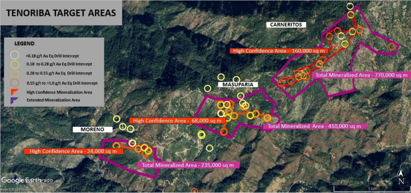
Adding 100% of the Target contained within the High Confidence area plus the target for further exploration contained within 100, 65, 50 and 35 percent of the Extended mineralized area, and considering only the mixed oxidized-sulfide/transition zone mineralized horizon within the three principal mineralized areas, yields 1,365,312, 980,237, 815,206 and 650,175 gold equivalent ounces, respectively. The following table illustrates the Velasco study Exploration Target gold Eq mineralization in each of the three principal mineralized areas at Tenoriba. The location and boundaries of the High Confidence and Extended Mineralized areas relative to the location of historical drilling are illustrated in Figure 1. Location Map, Drill Hole Collar Locations with Exploration Target Boundaries, Tenoriba Project.
Velasco Study - Exploration Target Gold Equivalent Mineralization, All Three Areas.
The Company recommends that resource definition drilling to define an Inferred mineral resource, following the recommended drill hole spacing, be advanced in the suggested three phases of drilling at Tenoriba. This recommendation follows from a combination of many hundreds of gold-silver sample values collected from the surface and in drill core within the three principal areas of mineralization at Tenoriba that were sampled coincident with features observed in ground geophysics, coupled with the high rates of gold-silver dissolution-recovery from the preliminary metallurgical tests and the range of values calculated for the Exploration Target, both in Mammoth’s internal study and re-confirmed by the Valesco study.
Quality Assurance and Quality Control (QA/QC):
All data provided for this drill spacing study followed QA/QC controls as outlined on the Mammoth Resources website, “News” and press releases spanning the period November 18, 2021 to December 15, 2022.
Qualified Person(s)/Competent Person(s) (QP/CP):
Richard Simpson, P.Geo., Vice-President Exploration for Mammoth Resources Corp. is Mammoth's QP/QC under National Instrument 43-101 by virtue of his professional designation, university degree and years of work experience as a geologist and is responsible for and has reviewed all technical data in this release (refer to Mammoth’s website “Projects”, “Qualified Person/Competent Person” section for Mr. Simpson’s qualifications).
Edgardo Espinosa Velasco is an experience geologist. He graduated in 1995 from the engineering faculty of the Universidad del Estado de San Luis Potosi, Mexico. Since graduating, Mr. Valesco has worked as a professional geologist for national and foreign exploration and mining companies in Mexico. Since 2004, he has been an active member of the Asociación de Ingenieros de Minas Metalurgistas y Geologos de Mexico and has held numerous director positions at the San Luis Potosí branch of the Asociación. In 2012 Mr. Valesco founded Caldera Drilling SA de CV, a Mexican drill contracting company that provides diamond drilling services for the civil engineering and mineral exploration industries in Mexico. Edgardo Espinosa Velasco is a QP/CP under NI 43-101 by virtue of his university degree, 17 years experience as a geologist and good standing in the Asociación de Ingenieros de Minas Metalurgistas y Geologos de Mexico.
About Mammoth Resources:
Mammoth Resources (TSX-V: MTH) is a precious metal mineral exploration Company focused on acquiring and defining precious metal resources in Mexico and other attractive mining friendly jurisdictions in the Americas. The Company holds a 100% interest (subject to a 2% net smelter royalty purchasable anytime within two years from commencement of commercial production for US$1.5 million) in the 5,333-hectare Tenoriba gold property located in the Sierra Madre Precious Metal Belt in southwestern Chihuahua State, Mexico. Mammoth is seeking other opportunities to option exploration projects in the Americas on properties it deems to host above average potential for economic concentrations of precious metals mineralization.
To find out more about Mammoth Resources and to sign up to receive future press releases, please visit the company's website at: www.mammothresources.ca., or contact Thomas Atkins, President and CEO at: 416 509-4326.
Neither the TSX Venture Exchange nor its Regulation Services Provider (as that term is defined in the policies of the TSX Venture Exchange) accepts responsibility for the adequacy or accuracy of this release.
Forward Looking Information: This news release may contain or refer to forward-looking information. All information other than statements of historical fact that address activities, events or developments that the Company believes, expects or anticipates will or may occur in the future are forward-looking statements; examples include the listing of its shares on a stock exchange and establishing Mineral Resources. These forward-looking statements are subject to a variety of risks and uncertainties beyond the Company's ability to control or predict that may cause actual events or results to differ materially from those discussed in such forward-looking statements. Any forward-looking statement speaks only as of the date on which it is made and, except as may be required by applicable securities laws, the Company disclaims any intent or obligation to update any forward-looking statement, whether a result of new information, future events or results or otherwise. Although the Company believes that the assumptions inherent in the forward-looking statements are reasonable, forward-looking statements are not guarantees of future performance and, accordingly, undue reliance should not be placed on these forward-looking statements due to the inherent uncertainty therein.
Figure 1. Location Map, Drill Hole Collar Locations with Exploration Target Boundaries, Tenoriba Project

