Red Canyon Drilling Confirms Discovery of Significant Copper- Molybdenum Mineral System at its 100% owned Kendal Project
 | |||||||||
 |  |  | |||||||
Vancouver, British Columbia - TheNewswire - November 5, 2024: Red Canyon Resources Ltd. (“Red Canyon” or the “Company”) (CSE: REDC | OTCQB: REDRF) is pleased to announce it has now completed the inaugural diamond drill program on its 100% owned Kendal Project in west-central British Columbia. The Company successfully drilled five diamond core holes, testing the northeastern area of the Kendal surface alteration system. All drill holes intersected significant porphyry-style alteration, multiple vein sets and variable visual copper and molybdenum (moly) mineralization throughout.
Company Highlights:
-
Five drill holes totalling 2,562 metres (“m”) have tested a portion of the upper 250 to 450 m of the Kendal system measured vertically from surface, and over an area covering approximately 1.0 km by 0.50 km of a mapped 2.5 km by 1.5 km alteration footprint.
-
Strong alteration is pervasive in all drill holes with multi-generational porphyry related veining identified throughout. Alteration is predominately propylitic to inner propylitic with areas of sericite (QSP), sericite-chlorite ± clay (SCC) and remanent potassic zones. Multi-generational veins, with copper and moly mineralized sets, suggest Kendal represents a large, mineralized copper-moly porphyry system.
-
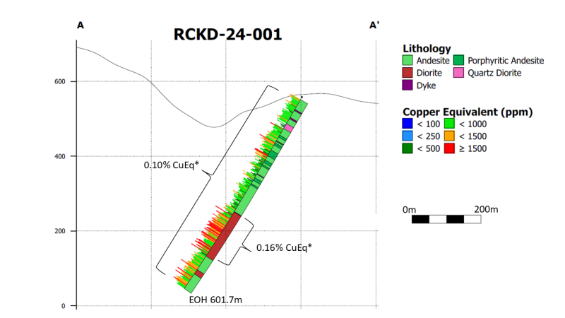
Assays received from the first drill hole (RCKD-24-001) at Kendal returned 0.10% CuEq* starting from surface to 601.7 m, including 123.0 m grading 0.16% CuEq*.
-
Drill intercepts are interpreted to represent zones of mineralization above or adjacent to an anticipated central higher-grade core within this mineralized calc-alkaline copper–moly porphyry system.
Wendell Zerb, the Chairman and CEO of the Company, states: "This first ever drill program at Kendal has not only confirmed a new copper–moly discovery, but it has also immensely expanded our confidence and understanding of the size and overall strength of the greater mineral system. Every drill hole, from top to bottom, is significantly altered with multiple vein sets representing a very robust mineral system. We are also confident this initial scout drill program has only “scratched” a portion of the copper–moly system, in a small subset of the overall Kendal project area. Copper–moly porphyry mines worldwide are some of the largest, highest value sources of metal and it’s especially rare for a small cap mineral exploration company to discover and control 100% of potentially a large copper-moly system, with importantly exceptional infrastructure”.
Dr. Craig Hart, Chief Geoscientist of the Company, states: – “The extensive mineralized alteration footprint encountered with these first-ever drill holes at Kendal, indicates a porphyry system with a massive amount of fluid flow. The large alteration footprint and corresponding multi-generations of hydrothermal veins give us confidence about the scale of the system and the potential to target towards a high-grade core. This early drill program at Kendal was a great success in confirming a copper porphyry discovery, and additional work is required to find the best of the Kendal system”.
Kendal Project
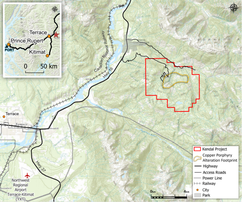
Kendal comprises five 100%-owned mineral claims totalling 2,738 hectares located in west-central British Columbia approximately 25 km northeast of the city of Terrace, a regional infrastructure hub with a well-serviced airport. Infrastructure is excellent with four intersecting highways, hydroelectric power, rail corridors, and port facilities approximately 120 km to the west at Prince Rupert. The project has direct road access, only 3.5 km from Highway 16. The project area lies within the traditional territory of the Kitselas First Nation.
Figure 1: Kendal Project location map with Red Canyon claims.
Kendal Project Drilling
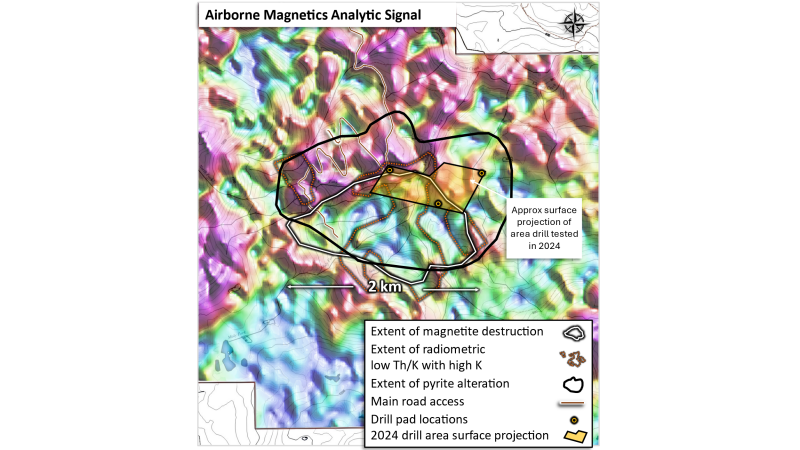
Red Canyon has completed the first ever diamond drill program at its 100% owned Kendal project. The program consisted of five drill holes totalling 2,562 m. Drilling targeted the northeastern portion of the Kendal copper-moly porphyry system, represented by significant altered and mineralized andesitic volcanic and porphyritic intrusive rocks exposed over 2.5 km x 1.5 km (Figure 2). Drill holes have been sampled from top to bottom with initial assays received from drill hole RCKD-24-001. Assays from all remaining holes are pending and anticipated by late December 2024 to early January 2025.
Figure 2: Kendal drill program test area. Magnetic analytic signal image over the central part of the Kendal project indicates a (> 2 km2) hydrothermal alteration footprint defined by a large zone of depressed magnetic response from potential hydrothermal magnetite destruction within a broader region of gossanous pyrite alteration.
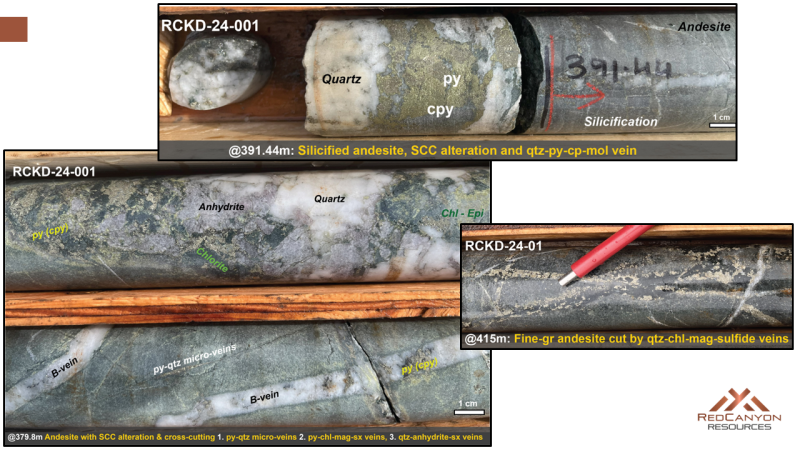
The 2024 drilling program at Kendal project confirmed the discovery of a substantial mineralized porphyry system with an extensive alteration footprint spanning a minimum of 1.5 km2. Drilling consistently intersected a succession of highly altered and mineralized volcanics and multiple cross-cutting quartz diorite and microdiorite porphyry intrusions. Multiple generations of hydrothermal veins cut across the porphyry intrusions and volcanic host rocks. Based on the vein mineralogy and cross-cutting relationships, at least seven vein generations have been identified, including multiple sets that host chalcopyrite and moly mineralization (Figure 3).
Figure 3: Select core samples from Kendal drill hole RCKD-24-001
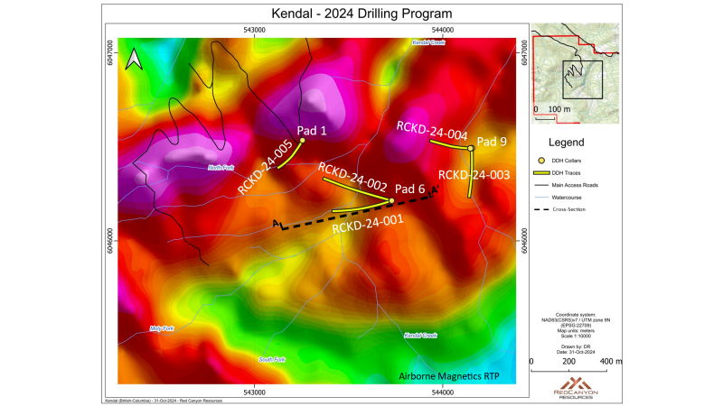
The drilling was conducted from three drill locations at Kendal: one road accessible pad on the west side of Kendal Creek and two helicopter-supported pads on the east side of Kendal Creek. Collar locations were set up at approximately 90 m to 115 m above the base of Kendal Creek. Drill holes RCKD-24-001, 002 and 005 targeted areas below exposed porphyritic intrusions in Kendal Creek and within the interpreted magnetic destruction zone coincident with gamma-ray radiometric signature with very low thorium/potassium (Th/K) ratios (Figures 2 and 4). Drill holes RCKD-24-003 and 004 tested magnetic high and low features with coincident elevated copper and moly geochemistry. Both drill holes were collared at relatively low elevation to test the northeast portion of the 2.5 km by 1.5 km surface alteration footprint.
Figure 4: Kendal drill plan with drill hole collars and traces on airborne magnetic RTP map.
Table 1 2024 Kendal Drill Hole Details
|
Hole |
UTM_Grid |
UTM_East |
UTM_North |
Collar elev |
Azimuth |
Dip |
TD |
|
m |
m |
||||||
|
RCKD-24-001 |
NAD83_Z9 |
543729 |
6046214 |
558 |
250° |
-60° |
601.7 |
|
RCKD-24-002 |
NAD83_Z9 |
543729 |
6046214 |
558 |
285° |
-55° |
604.7 |
|
RCKD-24-003 |
NAD83_Z9 |
544154 |
6046493 |
497 |
172° |
-58° |
452.9 |
|
RCKD-24-004 |
NAD83_Z9 |
544147 |
6046492 |
497 |
270° |
-60° |
395.0 |
|
RCKD-24-005 |
NAD83_Z9 |
543255 |
6046535 |
569 |
210° |
-69° |
507.8 |
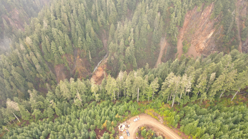
Figure 5: Drill pad location 1 (bottom), collar location for RCKD-24-005. Drone photo is looking south with Kendal Creek (far left) and North Fork drainages highlighting strong pervasive phyllic alteration.
Drill hole RCKD-24-001 (DH001) Azimuth 252 deg, Dip -60°
DH001 tested the Kendal alteration system collared from fly-in drill pad 06 on the east side of Kendal Creek (Figure 4). Drilling immediately encountered interlayered, porphyritic andesite, medium-grained phaneritic andesitic flows and volcaniclastics of Early Jurassic Telkwa Formation, cut by multiple diorite and microdiorite porphyry intrusions that are subsequently cut by intra-mineral quartz diorite and late-mineral feldspar porphyry dikes.
The porphyry intrusions and host andesitic volcanics have undergone intense propylitic (chlorite-epidote-carbonate-pyrite) alteration and silicification, which is overprinted by sericitic (QSP) and sericite-chlorite ± clay (SCC) alteration at deeper levels. This alteration suite is interpreted to be within the shell of a mineralized copper-molybdenum calc-alkaline porphyry system.
Figure 6: Cross Section A - A’ (Figure 4) Drill hole RCKD-24-001- looking north
Multi-generational porphyry-related veins are consistently intersected throughout the hole. Mineralization is associated with quartz veins and is consistently with ~3% to 4% pyrite and <0.5% chalcopyrite and <0.5% molybdenum. Quartz-chlorite-magnetite-sulfide vein densities increase at depth in the drill hole and generations of quartz-chlorite-magnetite-sulfide, quartz-anhydrite-chlorite-sulfide and micro-veinlets of pyrite all indicated a higher temperature zone from 375 to 450 m with a slight increase in chalcopyrite mineralization.
Table 2 Drill results from Kendal Project RCKD-24-001
|
Hole ID |
From |
To |
Interval |
Cu Grade |
Mo Grade |
Ag Grade |
CuEq* Grade |
Az |
Inc |
TD |
|
(m) |
(m) |
(m) |
(%) |
ppm |
ppm |
(%) |
(m) |
|||
|
RCKD-24-001 |
7.80 |
601.7 |
593.9 |
0.051% |
58.5 |
0.43 |
0.098% |
252 |
-60 |
601.7 |
|
including |
368.0 |
491.0 |
123.0 |
0.082% |
103.8 |
0.44 |
0.162% |
Copper Equivalent (CuEq) shown in the Table above are calculated on a basis of US$ 3.75/lb for Cu, US$ 25/oz for Ag and US$ 27.5/lb for Mo, with 80% metallurgical recoveries assumed for all metals (ie no assumptions have been made for recoveries at this stage). The formula is: CuEq. = Cu % + (Ag grade in g/t x (Ag recovery / Cu recovery) x [Ag price ÷ 31.1] / [Cu price x 2204.6] + (Mo grade in % x (Mo recovery / Cu recovery) x [Mo price x 2200] / [Cu price x 2204.6]).
Link to complete core photo library for RCKD-24-001
Drill hole RCKD-24-002 (DH002) Azimuth 285 deg Dip -55°
DH002 tested the Kendal alteration system collared from Pad 6 on the east side of Kendal Creek (Figure 4). Like DH001, DH002 drilling consistently intersected a succession of highly altered and mineralized andesitic volcanics and multiple cross-cutting quartz diorite and microdiorite porphyry intrusions.
A systematic pattern of hydrothermal alteration, veining and copper-sulphide mineralization in DH002 builds on the significant footprint of the Kendal porphyry system. The Company considers it noteworthy that the drill hole intersected multiple crosscutting porphyry intrusions including a possible causative intrusive at 365 m, responsible for the extensive >1.5 km2 wide alteration footprint at Kendal. This intrusion is a distinct phase of equigranular microdiorite, emplaced as stock and dikes to the end of hole at 604.7 m. The alteration intensities, vein-stockwork mineralization, magnetic intensity and periodic silica flooding, as well as remnant potassic alteration generally continued to increase with depth.
Link to complete core photo library for RCKD-24-002
Drill hole RCKD-24-003 (DH003) Azimuth 172 deg Dip -58°
DH003 is a 500 m step out to the NE from DH001/002 designed to test a magnetic high/low interface adjacent to elevated copper and moly rock and soil geochemistry. This fly-in location, Pad 9, is approximately 60 m lower elevation than Pad 6, on the northeast portion of the surface alteration footprint (Figure 4).
The drill hole intersected extensive andesitic volcanics characterized by strong propylitic alteration locally overprinted by intense silicification and hydrothermal magnetite. The andesite units are cut by small diorite dikes with faulted contacts subsequently invaded by late-quartz-carbonate-pyrite veins. Andesitic volcanics in this hole host a series of multi-generational veins that carry sulphide mineralization. The top 173 m of the drill hole highlighted a similar sequence of early to late-stage vein generations as identified in DH001/002.
The alteration intensity and vein densities fluctuate downhole with silicified zones representing vein stockwork mineralization, including B-veins and pyrite-chlorite-magnetite veins. The alteration changed from sericite-chlorite ± clay (“SCC”) to distal propylitic at 173 m indicating a more distal propylitic alteration to the end of hole.
DH003 are assays pending.
Link to complete core photo library for RCKD-24-003
Drill hole RCKD-24-004 (DH004) Azimuth 270 deg Dip -60°
DH004 was also collared from Pad 9, tested from the margins into a prominent 500 m2 wide magnetic anomaly, adjacent to elevated copper and moly rock and soil geochemistry.
DH004 cut extensive andesitic volcanics with repeated propylitic, sericite-chlorite alteration and silicification coincident with a sequence of multi-generational veins as identified in DH001/002. The upper 144 m indicated a gradual increase in the alteration intensity, vein densities and copper-sulphide mineralization down to 245 m.
The propylitically-altered andesite flows host multiple fluid pathways with intense silicification and 2% to 4% fine-grained disseminated magnetite, confirming the source of the magnetic anomaly targeted to the west of the drill hole collar. Hydrothermal magnetite was identified in association with distinctive quartz-pyrite-magnetite-chlorite veining. The alteration intensity fluctuates from silicified, magnetite-bearing inner propylitic to carbonate-rich outer propylitic alteration; the latter is typically confined to shear/fault structures. The drill hole ended in what is interpreted to be a post-mineral hornblende diorite dike.
DH004 are assays pending.
Link to complete core photo library for RCKD-24-004
Drill hole RCKD-24-005 (DH005) Azimuth 210 deg Dip -69°
DH005 was drilled to the south from Pad 1 located on the western access road (Figure 4). The drill hole targeted outcropping intrusive and andesitic volcanic rocks characterized by a cluster of overlapping gossans, geochemical copper, moly and magnetic anomalies seen in the Kendal Creek drainage approximately 90 m vertically below and south of the collar location.
The drill hole intersected a sequence of highly-altered andesitic rocks cut by multiple porphyry intrusions and post-mineral dikes. The andesitic volcanics are characterized by strong propylitic alteration and internal fluid pathways of intense silicification, hydrothermal magnetite and elevated chalcopyrite mineralization. Notable zones include a shallow hydrothermal breccia (42 to 55 m) characterized by up to 30 cm sub-rounded andesite/diorite clasts cemented in a siliceous matrix hosting blebs of coarse-grained pyrite ± chalcopyrite.
Downhole, andesite is intruded by quartz-diorite porphyry from 68 to 102 m characterized by intense silicification and patchy white argillic alteration. A distinct medium-grained diorite is emplaced as stock and dikes from 198 to 284 m. This diorite phase is characterized by variably pinkish colour interpreted as hematite dusting and staining in the groundmass. The diorite has undergone sericite-chlorite and propylitic alteration with intense silicification and ~2% magnetite. Mineralization consists of 3% to 4% pyrite with traces of chalcopyrite increasing with depth.
DH005 assays are pending.
Link to complete core photo library for RCKD-24-005
About Red Canyon Resources
Red Canyon Resources Ltd. (CSE: REDC | OTCQB: REDRF) is a geoscience-driven, discovery-focused mineral exploration company focused on exploring North America’s top copper jurisdictions. The Company’s core goal is to make impactful copper discoveries to benefit all stakeholders and support the clean energy transition. Red Canyon has a portfolio of 100%-owned copper and copper-gold porphyry exploration projects. The Company’s technical team consists of experienced geoscientists with diverse capital market, small cap and major mining company backgrounds and a track record of success.
For more information, please visit the Company's website at www.redcanyonresources.com.
Red Canyon is part of the NewQuest Capital Group which is a discovery-driven investment group that builds value through the incubation and financing of mineral projects and companies. Further information about NewQuest can be found on the company website at www.nqcapitalgroup.com.
On Behalf of the Board of Directors
Wendell Zerb, P. Geol
Chairman and Chief Executive Officer
+1 (604) 681-9100
For further information, please contact:
Brennan Zerb
Investor Relations Manager
+1 (778) 867-5016
The Canadian Securities Exchange does not accept responsibility for the adequacy or accuracy of this press release.
Qualified Person
The scientific and technical information contained in this news release has been reviewed and approved by Christopher J. Wild, P. Eng, Red Canyon’s Exploration Manager and a “Qualified Person” (“QP”) as defined in National Instrument 43-101 – Standards of Disclosure for Mineral Projects. Drilling at Kendal was conducted by Diamondhead Drilling using an Atlas Copco CS-1000 core drill rig. Initial drilling used HQ sized core to advance through up to 15 m of overburden and up to 50 m of broken or fractured rock. Once competency of the rock improved core size was reduced to NQ.
Core was received, geotechnically and geologically logged, photographed, and cut by core saw at the Company’s leased core facility in Terrace, British Columbia. Samples were laid out, cut and sampled to the Company’s specified sample intervals. Certified reference materials (CRM’s) including blanks and standards were inserted every 10 samples. Half core samples are placed in plastic sample bags with the remaining half retained in core boxes at the core facility. Samples are dispatched to ALS Laboratories facilities in Terrace, British Columbia, an accredited analytical laboratory meeting ISO/IEC 17025:2005 and ISO 9001:2015. Samples are prepared by crushing and grinding by ALS methods CRU-21 and PUL-32, respectively. The pulps are then analyzed for 36 elements by method ME-ICP41. Gold is assayed by fire assay using ALS method Au-AA23 using a 30g sample charge and AES finish. Laboratory standards and QA-QC are monitored by the Company.
Forward-Looking Statements:
This news release includes certain forward-looking statements and forward-looking information (collectively, “forward-looking statements”) within the meaning of applicable Canadian securities legislation. All statements, other than statements of historical fact, included herein including, without limitation, statements regarding future capital expenditures, exploration activities and the specifications, targets, results, analyses, interpretations, benefits, costs and timing of them, and the anticipated business plans and timing of future activities of the Company, are forward-looking statements. Although the Company believes that such statements are reasonable, it can give no assurance that such expectations will prove to be correct. Often, but not always, forward looking information can be identified by words such as “pro forma”, “plans”, “expects”, “may”, “should”, “budget”, “scheduled”, “estimates”, “forecasts”, “intends”, “anticipates”, “believes”, “potential” or variations of such words including negative variations thereof, and phrases that refer to certain actions, events or results that may, could, would, might or will occur or be taken or achieved. Forward-looking statements involve known and unknown risks, uncertainties and other factors which may cause the actual results, performance or achievements of the Company to differ materially from any future results, performance or achievements expressed or implied by the forward-looking statements. Such risks and other factors include, among others, risks related to the anticipated business plans and timing of future activities of the Company, including the Company’s exploration plans and the proposed expenditures for exploration work thereon, the ability of the Company to obtain sufficient financing to fund its business activities and plans, the ability of the Company to obtain the required permits, changes in laws, regulations and policies affecting mining operations, the Company’s limited operating history, currency fluctuations, title disputes or claims, environmental issues and liabilities, as well as those factors discussed under the heading “Risk Factors” in the Company’s prospectus dated October 12, 2023 and other filings of the Company with the Canadian Securities Authorities, copies of which can be found under the Company’s profile on the SEDAR website at www.sedar.com.
Readers are cautioned not to place undue reliance on forward-looking statements. The Company undertakes no obligation to update any of the forward-looking statements, except as otherwise required by law.
