Archive
South Atlantic Gold's Drone Survey Identifies Multiple Sub-Surface Structural Features Coincident with Previously Defined Gold Mineralization
 | |||||||||
 |  |  | |||||||
Kelowna, British Columbia – TheNewswire - June 13, 2022 - SOUTH ATLANTIC GOLD INC. (TSXV:SAO) (OTC:JLRRF) (“South Atlantic” or the “Company”) announces another milestone for the Phase II exploration program which included a high-resolution Unmanned Airborne Vehicle (“UAV” or “drone”) magnetic survey at its 100 percent (“%”) owned Pedra Branca project, located in Ceará state, northeastern Brazil. The initial results of the UAV survey define a distinct signature over areas of known mineralization that, when combined with other datasets demonstrates the potential for gold mineralization to extend well beyond the limits of the current resource ( click here for technical report and here for UAV program news release dated April 8, 2022 ).
Highlights
-
Licensing and Permitting: The Company filed exploration reports required by Agencia Nacional de Mineração (“ANM”), the Brazilian mining agency, on-time and secured legal status for 15 tenements.
-
Phase I and II Exploration Consolidation: Click here for a table of total exploration work for both Phase I and Phase II. Pedra Branca consolidated exploration now has a total of 165 Reverse Circulation and 90 Diamond Drill (historical) holes with a total of 15,592 meters (“m”) drilled and 9,353 samples assayed. The RC hole depth averaged 38.5 m. Consolidated results can be seen here with previously published data available on our website.
-
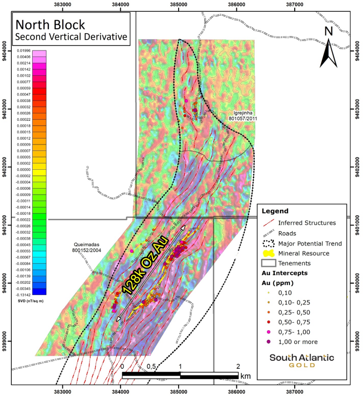
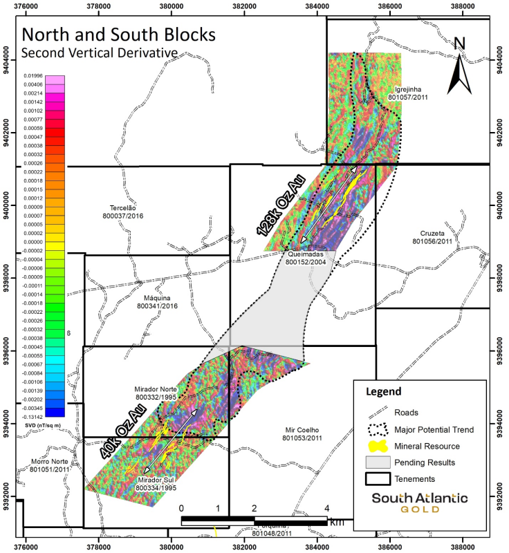
Magnetic Signature: The high-resolution drone survey has identified geological structures that are coincident with previously defined gold mineralization. These geological structures have been delineated farther than the extents of the known gold mineralization and provide numerous targets that will need to be tested with further exploration.
-
Phase II was completed on time and on budget.
Douglas Meirelles, CEO stated, “The Phase II exploration program enabled the Company to successfully deliver 15 detailed exploration reports to ANM which required very specific exploration work and, in addition to meeting these requirements, we also successfully completed the drone magnetic survey. The initial results of the drone survey added another dimension to the collective Phase I and II exploration program results, with several new targets identified.
“The continued consolidation of exploration data and new magnetics results confirm the previous geological model—including the lengthening of previously identified mineralized trends—along with the discovery of structures requiring further geological work. With several new compelling targets, the path forward for Pedra Branca is clear and further drilling will help define the boundaries of this district-scale asset.”
Consolidated Exploration
The completion of the drone magnetic survey provided significant results that will help guide and focus the next steps of the exploration program. In the National Instrument 43-101 technical report, click here to view (NI 43-101 report standards dated April 25, 2021 and entitled “Mineral Resource Estimation for the Pedra Branca Gold Project Ceará State – Brazil” authored by Rodrigo Mello, FAusIMM, of RBM Consultoria Mineral Belo Horizonte, Brazil filed under the Company’s profile on the SEDAR website at www.sedar.com), the largest target, Queimadas, has an Inferred Resource of 3.2 million tonnes grading 1.24 grams per tonne gold for 128,000 ounces Au at an average 40 meters depth. The magnetic signature at this target leaves the possibility to expand the current Inferred resource with additional drilling. Click here to see the resource statement qualification statements.
As seen on the map below, the section of Queimadas is contrasted with the consolidated exploration programs completed at surface (average 40 m depth) in conjunction with the magnetic survey, demonstrating the new potential of this entire target area.
The drone survey also highlighted the area between Mirador and Queimadas as seen on the map below, which greatly aided the interpretation of the structures that connects these two main targets for a total length of 60 km. The Company has also completed the magnetic survey between these two areas and is expecting to receive the data in the next few weeks.
Total Exploration from Phases I and II
In the 1.5 years that South Atlantic has been exploring the Pedra Branca property, a significant amount of current and historical work has been completed within a limited budget. This geological work provides a basis for the initial understanding of the mineralization at Pedra Branca.
Exploration Results for Phase I and II Combined
|
Activity |
Unit |
Phase I |
Phase II |
Total |
|
Stream Sediment Sample |
Samples |
0 |
231 |
231 |
|
Soil Sample |
Samples |
0 |
1,239 |
1,239 |
|
Trenching |
# |
92 |
48 |
140 |
|
Meters |
12,324 |
9,966 |
22,290 |
|
|
Samples |
12,170 |
5,038 |
17,208 |
|
|
RC Drilling |
# |
122 |
43 |
165 |
|
Meters |
5,022 |
1,657 |
6,679 |
|
|
Samples |
5,022 |
729 |
5,751 |
|
|
DD Drilling (Historical – performed in 2007/2008 by Jaguar Mining) |
# |
90 |
||
|
Meters |
8,913 |
|||
|
Samples |
3,602 |
Geophysics
One of the important take-aways from the geophysical program is that the ore intercepts are seen to be concentrated at the flexures between magnetic highs (red and pink colors) and magnetic lows (blue color) at Queimadas, Mir-Quelho and Mirador Norte target areas. An interesting gap located to the south, southeast and northeast of the Inferred resource area of Queimadas has been interpreted as areas of interest from the geophysical data (see map below).
The density of the geophysical grid allows the trendlines in the gaps between Queimadas and Mirador and similar geophysical structures in the southern portion of Pedra Branca. These trendlines are clear in the mafic domain where most of the ore/mineralization is accompanied by magnetic minerals (pyrrhotite).
The geophysics results have identified dozens of potential mineralized-like anomalies that have not yet been investigated in the Phase I and II exploration programs. A host of prospective exploration targets have been identified from the magnetic results. These prospective targets require investigation as they may provide important geological information to resolve questions on structural issues.
Qualified Person’s Statement
The scientific and technical information that forms the basis for parts of this news release was reviewed and approved by Marcelo Antonio Batelochi (P.Geo.), MAUSIMM (CP), the Company’s Exploration Manager who is a Qualified Person as defined by NI 43-101.
The mineral resource estimate is that material within the block models using a cut-off grade of 0.4 g/t Au. The effective date for the mineral resource is March 16, 2021 and a corresponding technical report disclosing the mineral resource estimate in accordance with NI 43-101 was prepared by RBM Consultoria Mineral for the Company endorsed by Mr. Rodrigo Mello, FAusImm. Mr. Mello is also a QP as defined under NI 43-101. South Atlantic filed the technical report on SEDAR at www.sedar.com.
About South Atlantic Gold
South Atlantic Gold is an exploration company engaged in acquiring and advancing mineral properties located in the Americas. Our flagship asset is the 100%-owned Pedra Branca project, located 280 km southwest of Fortaleza, Ceará State, Brazil. South Atlantic Gold is focused on creating value for its shareholders by engaging in the development and acquisition of high-quality mineral assets located in stable and mining-friendly jurisdictions. South Atlantic Gold is based in Kelowna, British Columbia, and is listed on the TSX-V under the symbol “SAO”.
ON BEHALF OF THE BOARD
Douglas Meirelles, President and CEO
For more information regarding this news release, please contact:
Anne Hite, Vice President, Investor Relations
T: 250-762-5777
Email: ir@southatlanticgold.com
Cautionary Note Regarding Forward-Looking Information
This news release contains statements that constitute "forward-looking Information", as such term is used in applicable Canadian securities laws. Such forward-looking information involves known and unknown risks, uncertainties and other factors that may cause the Company’s actual results, performance or achievements, or developments in the industry to differ materially from the anticipated results, performance or achievements expressed or implied by such forward-looking information. Forward-looking information includes statements that are not historical facts and are generally, but not always, identified by the words "expects," "plans," "anticipates," "believes," "intends," "estimates," "projects," "potential" and similar expressions, or that events or conditions "will," "would," "may," "could" or "should" occur.
Although the Company believes the forward-looking information contained in this news release is reasonable based on information available on the date hereof, by its nature forward-looking information involves assumptions and known and unknown risks, uncertainties and other factors which may cause our actual results, level of activity, performance or achievements, or other future events, to be materially different from any future results, performance or achievements expressed or implied by such forward-looking information. There can be no assurance that the Fundamental Acquisition will be completed as proposed or at all.
Examples of such assumptions, risks and uncertainties include, without limitation, assumptions, risks and uncertainties associated with general economic conditions; the Covid-19 pandemic; adverse industry events; the receipt of required regulatory approvals and the timing of such approvals; that the Company maintains good relationships with the communities in which it operates or proposes to operate, future legislative and regulatory developments in the mining sector; the Company’s ability to access sufficient capital from internal and external sources, and/or inability to access sufficient capital on favorable terms; mining industry and markets in Canada and generally; the ability of the Company to implement its business strategies; competition; the risk that any of the assumptions prove not to be valid or reliable, which could result in delays, or cessation in planned work, risks associated with the interpretation of data, the geology, grade and continuity of mineral deposits, the possibility that results will not be consistent with the Company’s expectations, as well as other assumptions risks and uncertainties applicable to mineral exploration and development activities and to the Company, including as set forth in the Company’s public disclosure documents filed on the SEDAR website at www.sedar.com.
THE FORWARD-LOOKING INFORMATION CONTAINED IN THIS NEWS RELEASE REPRESENTS THE EXPECTATIONS OF THE COMPANY AS OF THE DATE OF THIS NEWS RELEASE AND, ACCORDINGLY, IS SUBJECT TO CHANGE AFTER SUCH DATE. READERS SHOULD NOT PLACE UNDUE IMPORTANCE ON FORWARD-LOOKING INFORMATION AND SHOULD NOT RELY UPON THIS INFORMATION AS OF ANY OTHER DATE. WHILE THE COMPANY MAY ELECT TO, IT DOES NOT UNDERTAKE TO UPDATE THIS INFORMATION AT ANY PARTICULAR TIME EXCEPT AS REQUIRED IN ACCORDANCE WITH APPLICABLE LAWS.
Neither the TSX Venture Exchange nor its Regulation Services Provider (as that term is defined in the policies of the TSX Venture Exchange) accepts responsibility for the adequacy or accuracy of this release.

