Archive
Golden Ridge Resources Commences Major Field Program at the Heritage Project
 | |||||||||
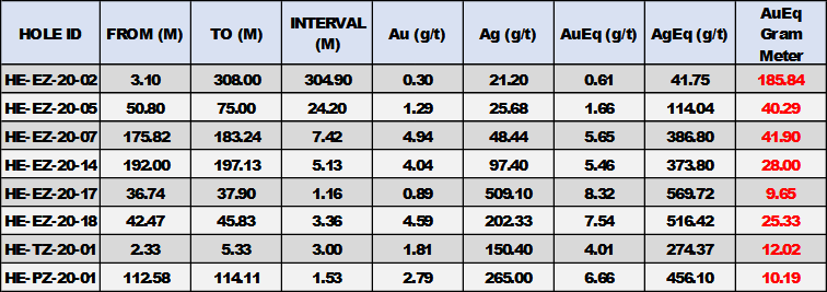
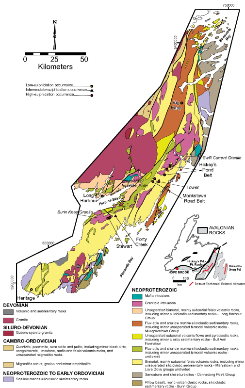
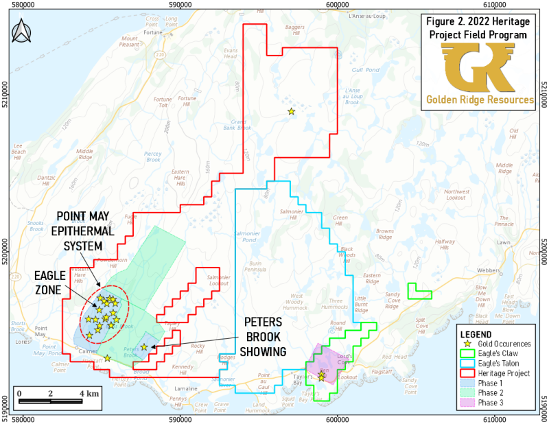
Kelowna, British Columbia – TheNewswire - September 29, 2022 - Golden Ridge Resources Ltd. (“Golden Ridge” or “the Company”) (TSXV:GLDN) (OTC:GORIF) is pleased to announce commencement of a 2,500 station, till geochemistry program at the Heritage Project (“Heritage” or “the Property”), located within the underexplored Burin Peninsula Epithermal Gold/Silver Belt in southern Newfoundland. Several high- and low-sulphidation epithermal systems have been identified throughout the Burin Peninsula Epithermal Belt (Figure 1).1 Gold and silver mineralization within the Heritage Project area was first discovered in 2010 and early outcrop and float samples returned assays of up to 117 g/t gold in one sample, and 72 g/t gold and 1,168 g/t silver in another.2 Exploration since 2010 has resulted in the discovery of numerous additional mineralized showings throughout the 22,875-ha Heritage Project area, including the Eagle Zone , 500m in strike length, within the Point May Epithermal System (Figure 2). In 2020 Golden Ridge completed 5,182m of drilling on Property, focused on the Eagle, Turpin, and Pinnacle Zones (all within the Point May Epithermal System) with broad and narrow mineralized intersections including 305 metres of 21.2 g/t Ag and 0.3 g/t Au and 3.36 metres of 202.33 g/t Ag and 4.59 g/t Au (see December 2, 2020, News Release; Table 1).3
Table 1 – Highlighted 2020 Heritage Project Drilling Intersections4

Till Geochemistry Program Details
The 2022 till geochemistry program will focus on and around previously identified geophysical and geochemical anomalies with the specific purpose of expanding the Eagle, Turpin, and Pinnacle Zones along strike, as well as generating additional targets. The program will be guided by the results of the 2020 high-resolution airborne magnetic survey, which proved highly effective due to the low topographic relief in defining potential geophysical anomalies (see November 24, 2020, news release).
The sampling program will proceed as follows:
Phase 1: 1,200 stations across two separate 200m x 25m grids centered on the Point May Epithermal System and the Peter’s Brook Showing to establish more clearly the full strike length of the known mineralized zones.
Phase 2: 1,000 stations on a coarser 400m x 50m grid over the underexplored portions of the Heritage Project area. Earlier prospecting and mapping located gold mineralization; however, this portion of the property lacks systematic geochemical coverage.
Phase 3: 300 stations on a 200m x 25m grid focusing on the Eagle’s Claw showing of the Heritage Project. Historic rock samples in the area have yielded up to 4.0 g/t Au, however the Eagle’s Claw area lacks systematic mapping, prospecting, and till-sampling coverage.2
“Golden Ridge is excited to begin the till geochemistry program on the Heritage Project in conjunction with the maiden drill program on the Williams Gold Property. Our 2022 field program will continue to highlight the Heritage Project as a district-scale opportunity for future exploration. The Burin Peninsula shows all the characteristics of a robust gold and silver epithermal belt, and Golden Ridge intends to use methods and understanding gained from exploring the Point May Epithermal System to continue to grow the Heritage Project and home into the best targets.”, stated Mike Blady, CEO and Director of Golden Ridge.
1This news release contains information about adjacent properties on which Golden Ridge has no right to explore or mine. Readers are cautioned that mineral deposits on adjacent properties are not indicative of mineral deposits on the Company’s properties
2The Company’s QP, as defined under NI 43-101, has neither prepared nor verified the quality of the historical data.
3 The intervals reported in these tables represent drill intercepts and insufficient data are available at this time to state the true thickness of the mineralized intervals. All gold values are uncut.
4 Gold and Silver equivalent is calculated using 0.0146 ratio.
Figure 1- Regional geology map of the western Avalon Zone of Newfoundland, with key epithermal prospects indicated (modified from Sparkes and Dunning, 2014; O’Brien et al., 1998).
Qualified Person:
Dr. Stephen Amor, PhD, PGeo, technical advisor to the Company, is the Qualified Person as defined by National Instrument 43-101 who has reviewed and approved the technical data in this news release.
Acknowledgments:
Golden Ridge Resources acknowledges the financial support of the Junior Exploration Assistance Program, Department of Industry, Energy, and Technology, Government of Newfoundland and Labrador.
About Golden Ridge Resources:
Golden Ridge is a TSX-V listed exploration company engaged in acquiring and advancing mineral properties located in Newfoundland and British Columbia. Golden Ridge is currently focused on exploration and development of its portfolio of exploration assets in Newfoundland. The Company owns a 100% interest in the 1,700-hectare Hank copper-gold-silver-lead-zinc property and the 3,000-hectare Hickman copper-gold property located in the Golden Triangle district, approximately 140 kilometres north of Stewart, British Columbia and has a portfolio of exploration projects in Newfoundland.
Golden Ridge Resources Ltd.
Mike Blady
Chief Executive Officer
Tel: (250) 717-3151
Website: www.goldenridgeresources.com
Cautionary Note Regarding Forward-Looking Statements
Certain statements contained in this news release, constitute "forward-looking information" as such term is used in applicable Canadian securities laws. Forward-looking information is based on plans, expectations and estimates of management at the date the information is provided and is subject to certain factors and assumptions, including: that the Company's financial condition and development plans do not change as a result of unforeseen events, that the Company obtains required regulatory approvals, that the Company continues to maintain a good relationship with the local project communities. Forward-looking information is subject to a variety of risks and uncertainties and other factors that could cause plans, estimates and actual results to vary materially from those projected in such forward-looking information. Factors that could cause the forward-looking information in this news release to change or to be inaccurate include, but are not limited to, the risk that any of the assumptions referred to prove not to be valid or reliable, which could result in delays, or cessation in planned work, that the Company's financial condition and development plans change, delays in regulatory approval, risks associated with the interpretation of data, the geology, grade and continuity of mineral deposits, the possibility that results will not be consistent with the Company's expectations, as well as the other risks and uncertainties applicable to mineral exploration and development activities and to the Company as set forth in the Company's Management’s Discussion and Analysis reports filed under the Company's profile at www.sedar.com. There can be no assurance that any forward-looking information will prove to be accurate, as actual results and future events could differ materially from those anticipated in such statements. Accordingly, the reader should not place any undue reliance on forward-looking information or statements. The Company undertakes no obligation to update forward-looking information or statements, other than as required by applicable law.
Neither the TSX Venture Exchange nor its Regulation Services Provider (as that term is defined in the policies of the TSX Venture Exchange) accepts responsibility for the adequacy or accuracy of this release.

