Archive
Grid Battery Metals Completes Phase 2 of its 2024 Clayton Valley Project 2024 Exploration Plan
 | |||||||||
 |  |  | |||||||
Coquitlam, BC – TheNewswire - June 20, 2024 - Grid Battery Metals Inc. (the “Company” or “Grid”) (TSXV: CELL, OTCQB: EVKRF FRA: NMK2) is pleased to announce the conclusion of a second phase of soil samples and the construction of a geologic model incorporating mapped geology, magnetotelluric (MT) geophysics, and soil geochemistry. Grid’s exploration team has determined that a multilayered approach to drill targets would improve the chances of intercepting lithium bearing brines.
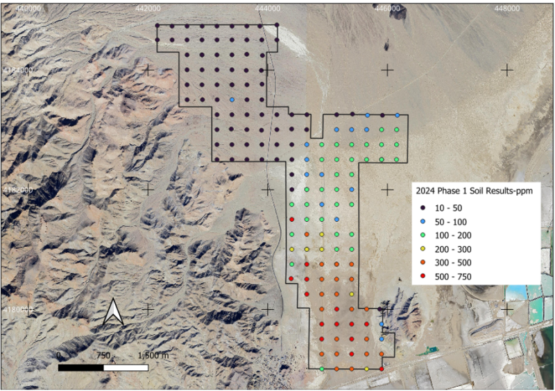
The initial soil sample program was completed in March 2024 and consisted of 166 samples on a 250 x 250 meter grid. The results of this program show a sizeable cluster of +300 ppm samples at the south end of the claims, and a generally northeast trending cluster of 100-300 ppm samples that extend to the north-central portion of the claims (Figure 1).
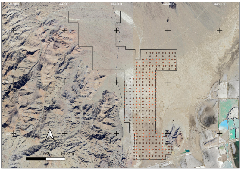
A second infill phase was completed in early May 2024 over a 125 x 125 meter grid (Figure 2) and consists of 286 samples. The objective of the infill sampling is to refine grade breaks identified in phase 1 to better focus drill targeting. Assay results are pending.
Recent Infill Soil Samples Taken (Clayton Valley Lithium Project)
Figure 1: Clayton Valley Phase 1 soil sampling results.
Figure 2: Clayton Valley infill Phase 2 soil samples.
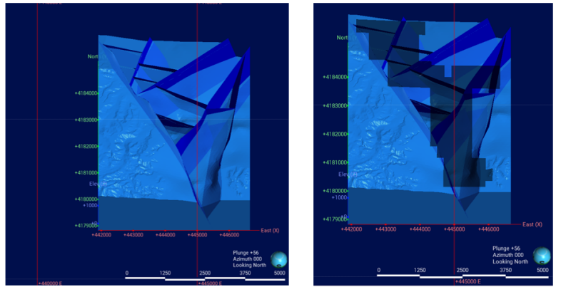
To better understand the underlying structure of the Clayton Valley claims, 2024 MT data, and publicly available geologic maps and DEM data were incorporated into a Leapfrog model by Mr. Ben Hinkley of Rangefront Mining Services. The geologic mapping used is from a 2008 summary report of a geothermal exploration program in Clayton Valley in 2007 (Hulen, 2008). Both mapped and inferred faults were used to create fault blocks. Figure 3 shows the geologic map used, and the Grid land shape both draped on a topographic DEM.
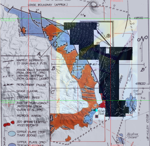
Figure 3: A Leapfrog model with faults and fault blocks. The darked image to the right of the topographic DEM image includes the Grid land shape.
Figure 4: Oblique view of the Clayton Valley geologic model without claims on the left and with claims on the right.
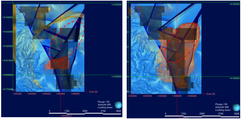
Apparent resistivities and XYZ coordinates from each MT (1d and 2d) line were imported into Leapfrog as a numeric model, and isosurfaces (3d contours) were generated for various resistivities. 2D resistivities of <1 and 1-5 show the tightest structural focus to the northeast suggesting the most conductive brine is focused along the circled northeast fault (Figure 5).
Figure 5: 2D resistivity isosurfaces for <1 ohm-m on the left and 1-5 ohm-m on the right
All soil assays will be contoured as a horizontal surface and will then be draped on topography in Leapfrog. The expectation is that the soil contours and MT contours will enable the best placement of drillholes that are driven by structure, geophysics, and geochemistry.
Grid’s Clayton Valley Lithium Project (RC Drilling Locations Identified)
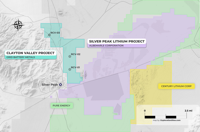
Tim Fernback, Grid President & CEO comments “Recently, Century Lithium (TSXV: LCE, OTCQB: CYDVF) our neighbor to the east) has just released their Positive Feasibility Study by T. Lane et al. (2024). Measured and Indicated resources totaling 1,207.33 million tonnes (Mt) at an average grade of 957 parts per million (ppm) lithium (Li) containing 1.155 Mt of Li or 6.148 Mt of lithium carbonate equivalent (LCE), a 40-year mine life and an after-tax NPV8 of $3.01 billion. Additional information is in Century Lithium’s NI-43-101 by Fayram et al. (2020) 43-101 Report. Clayton Valley Nevada is home to North America’s only lithium brine producer (Albemarle Corporation’s (NYSE: ALB) Silver Peak Mine) and our property is immediately to the west of their lithium property and production facility. We are very excited about our work completed to date and look forward to our assay results so we can continue to generate shareholder value in this prolific lithium producing region of Nevada.”
It should be noted that results from any adjacent property(s) are not an indication of what may be found on the Company’s property(s).
About Rangefront Geological
Elko Nevada-based Rangefront Geological has combined in-depth expertise with cutting-edge technology to provide mining consulting services, contract labor, field crew services, and vehicular support to the mining industry. With services available across North America, Rangefront works closely with its clients to provide high-quality mineral exploration services.
Qualified Person
Mr. Steven McMillin, P.G. is a Qualified Person as defined by National Instrument 43-101 and has approved the technical information contained within this news release.
About Grid Battery Metals Inc.
Grid Battery Metals Inc. is a Canadian based exploration company whose primary listing is on the TSX Venture Exchange. The Company’s maintains a focus on exploration for high value battery metals required for the electric vehicle (EV) market.
The Company owns a 100% interest in the Texas Spring Property which consists of mineral lode claims located in Elko County, Nevada. The Property is in the Granite Range southeast of Jackpot, Nevada, about 73 km north-northeast of Wells, Nevada. The target is a lithium clay deposit in volcanic tuff and tuffaceous sediments of the Humbolt Formation. A Phase 1 exploration program at the Texas Springs Property (Fall 2023) yielded average lithium grades of 2010 ppm, applying a 1,000 ppm cut-off, and up to 5,610 ppm Lithium.
The Texas Spring property adjoins the southern border of the Nevada North Lithium Project - owned by Surge Battery Metals Inc. (“Surge”) (TSXV: NILI, OTC: NILIF) and comprised of 725 mineral claims. Surge's first round of drilling identified strongly mineralized lithium bearing clays. The average lithium content within all near surface clay zones intersected in the 2022 drilling program, applying a 1000 ppm cut-off, was 3254 ppm. (Press release March 29, 2023). More recent results have shown higher grade lithium up to 8070 ppm on this property after initial drilling (Press release September 12, 2023). Our exploration results are on-trend with these results.
About Clayton Valley Lithium Project
The Company owns a 100% interest in 113 lithium lode and placer claims covering over 640 hectares in Clayton Valley. Clayton Valley is a down-dropped closed basin formed by the Miocene age Great Basin extension and is still active due to movement along the Walker Lane structural zone. As a result, the basin has preserved multiple layers of lithium bearing volcanic ash, resulting from multiple eruptive events over the past 6 million years including eruptions from the 700,000-year-old Long Valley Caldera system and related events. These ash layers are thought to contribute to the lithium brines extracted by Albemarle and are also likely involved in the formation of the exposed lithium rich clay deposits on the east side of Clayton Valley.
The Company owns a 100% interest in 80 placer claims covering approximately 635 hectares of alluvial sediments and clays located 122 km northeast of Tonopah, Nevada.
References
Hulen, Jeffrey B., 2008, Geology and Conceptual Modeling of the Silver Peak Geothermal Prospect, Esmeralda County, Nevada, Technical Report for Sierra Geothermal Power Corporation, http://gdr.openei.org/files/268/Silver%20Peak%20Geology%20Map%20and%20Model%20(Hulen)%20Jul%202008.pdf.
Prefeasibility Study Clayton Valley Lithium Project, Esmerelda County, Nevada, August 5, 2020, Amended March 15, 2021, Todd Fayram MMSA-QP (CMS), Terre A. Lane MMSA-QP (GRE), J.J. Brown, SME-RM (GRE), NI43-101 Technical Report for Century Lithium
Century Lithium Announces Positive Feasibility Study for the Clayton Valley Lithium Project, Nevada, April 29, 2024, Terre A Lane MMSA-QP (GRE), Hamid Samari, Principal Geologist, Todd-Fayram, Sr. V.P Metallurgy-Century Lithium, Alan Drake, Process Engineering, Haiming (Peter)Yuan Principal Geotechnical Engineer, Paul Blauch, Technical Director, Farza Kossari, Cost Estimating Engineer, Century Lithium Press Release.
On Behalf of the Board of Directors
Email: info@gridbatterymetals.com
Neither the TSX Venture Exchange nor its Regulation Services Provider (as that term is defined in the policies of the TSX Venture Exchange) accepts responsibility for the adequacy or accuracy of this release. This news release may contain forward-looking statements which include, but are not limited to, comments that involve future events and conditions, which are subject to various risks and uncertainties. Except for statements of historical facts, comments that address resource potential, upcoming work programs, geological interpretations, receipt and security of mineral property titles, availability of funds, and others are forward-looking. Forward-looking statements are not guarantees of future performance and actual results may vary materially from those statements. General business conditions are factors that could cause actual results to vary materially from forward-looking statements. It should be noted that results from any adjacent property(s) are not an indication of what may be found on the Company’s property(s).
