Archive
Highlander Silver Reports New Surface Discovery and Defines Drill Targets at Alta Victoria, Peru
 | |||||||||
 |  |  | |||||||
November 11, 2021 - TheNewswire - Vancouver, British Columbia – Highlander Silver Corp. (CNSX:HSLV.CN) (OTC:LDOMF) (the “Company” or “Highlander”) is pleased to report ongoing progress of surface exploration and drill target generation work at its 71km2, Alta Victoria silver-polymetallic project (the “Project”) located in the prolific, Miocene polymetallic mineral belt of central Peru.
Highlights
-
- Systematic surface work has led to the identification of the “Marca Plata” target in the northern concession block. A 200-metre diameter zone defined by anomalous lead in soils returned select channel samples of 3.3m @ 68.5 g/t Ag, 1.43% Pb and 0.7% Zn and 11.1m @ 104.4 g/t Ag, 4.27% Pb and 0.22% Zn (see Table 1 below).
- Integration of the recent gravity and magnetic survey results has revealed a gravity anomaly at shallow depths, coincident with the dip of the stratigraphy beneath a 300 x 100 metre zone of altered and mineralized limestones. Rock chip samples range in grades of up to 280 g/t Ag, with variable Cu to 0.50%, Pb up to 11.2% and Zn up to 29% (see Table 2 below).
- The magnetic survey shows magnetic highs adjacent to IP-chargeability highs with coincident high level multi-element geochemical anomalies in surface sampling in areas of historic mining activity.
“Our interpretation of the recent geophysical survey results, coincident with anomalous geochemistry supported by favorable structural and stratigraphic setting provides us with a series of compelling drill targets that we intend to test during the next drill season. Additionally, the discovery of the entirely new Marca Plata target in the northern concession block demonstrates the prospective nature of the Alta Victoria Property. Based on our success, we plan on expanding our field crew to broaden our search across the entire property,” said Ron Stewart, President and CEO of Highlander.
Marca Plata Prospect – New Target Discovery
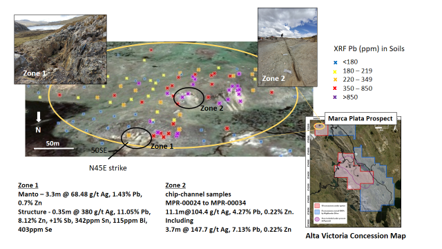
Recent field work completed in the northern concession block, 3 km north of the core claims has identified a 200-metre diameter lead in soil anomaly. X-Ray Fluorescence (pXRF) lead values in soil range from 180ppm to >850ppm within sedimentary rocks of the Carhuaz Formation (Figure 1). Channel sampling of manto mineralisation in NE striking, SE dipping sandstone at Zone 1, returned 3.3 metres grading 68.5 g/t Ag, 1.43% Pb and 0.7% Zn. Sampling from a select, high-grade structure returned 0.35 metres grading 380 g/t Ag, 11.05% Pb and 8.12% Zn also containing anomalous antimony (+1%), tin (342ppm), bismuth (115ppm) and selenium (403ppm). The tin-bismuth-selenium values suggest the possibility of a proximal intrusive source of the metals. At Zone 2, channel sampling returned 11.1 metres averaging 104.4 g/t Ag, 4.27% Pb, 0.22% Zn including 3.7 metres at 147.7 g/t Ag, 7.13% Pb, 0.22% Zn. Controls to mineralisation are both structural and stratigraphic and form a visibly altered package of outcropping sediments striking northeast and dipping moderately to the southeast.
|
Table 1: Marca Plata Initial Sampling Highlights |
||||
|
Zone |
Width (m) |
Ag g/t |
Pb% |
Zn% |
|
Zone 1 |
3.3 |
68.5 |
1.43 |
0.70 |
|
including |
0.9 |
155.2 |
3.00 |
1.56 |
|
select structure |
0.35 |
380.0 |
11.05 |
8.12 |
|
Zone 2 |
11.1 |
104.4 |
4.27 |
0.22 |
|
including |
3.7 |
147.7 |
7.13 |
0.22 |
This area is complex structurally; younger, sub-volcanic diatreme rocks crop out in the immediate vicinity that may suggest a temporal and genetic relationship to mineralisation. Additional work is required to better understand the scale and potential of this prospect.

FIGURE 1: Marca Plata Prospect
Integrated Geology, Geophysics & Geochemistry
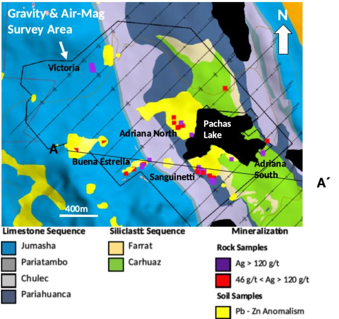
On September 9, the Company announced the completion of a geophysical survey over the Pachas Area target zone in the northwestern part of the southern concession block of the Property (Figure 2). This program comprised 37 NW-SE lines carried out by UAV (drone) magnetometer survey for a total of approximately 61 line-kilometres. Ground gravity measurements were carried out on a 100m x 100m grid for a total of 270 field stations with all stations surveyed using differential GPS. A high-resolution digital elevation model (DEM) was developed over the area prior to the start of the survey in order to facilitate the processing and interpretation of the data. The final report has been delivered and this data has been integrated with detailed mapping and geochemical sampling resulting in more clearly defined drill targets as shown in the illustrations below.
FIGURE 2: Geophysical Survey Area

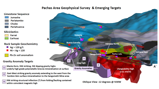
Combining the geophysics with the surface geochemistry reveals a strong spatial correlation of the anomalous features. Figure 3, presents a isometric slice along A - A’ showing the gravity highs (purple), magnetics (grey) and IP chargeability (red) lying beneath a lead-zinc soil anomaly with associated high grade silver grab samples. While magnetics and IP (chargeability) form broad anomalies, the gravity anomalies occur as well defined, discreet bodies that represent prospective drill targets with higher density (rock mass).
Gravity Anomaly 1, directly beneath the Buena Estrella target appears to conform to the down-dip projection of the stratigraphy beneath a 300 x 100 metre zone of altered and bleached limestones. Previously reported surface rock chip sampling in this area has returned some highly anomalous results, summarized in Table 2.
|
Table 2: Buena Estrella Select Rock Sample Geochemistry |
|||||
|
Sample # |
Au g/t |
Ag g/t |
Cu% |
Pb% |
Zn% |
|
3418 |
0.128 |
206 |
0.59 |
8.1 |
17.7 |
|
3419 |
0.068 |
286 |
0.51 |
5.5 |
29.0 |
|
210209 |
0.02 |
50 |
0.03 |
1.3 |
12.4 |
|
210421 |
0.12 |
270 |
0.34 |
11.2 |
23.7 |
|
210422 |
0.02 |
106 |
0.15 |
4.2 |
11.4 |
Gravity Anomaly 2, appears as an elongate, east-west roughly cylindrical zone projecting from the western most surface exposure of the Sombra vein. The Sombra vein is a 0.5 to 2 metre wide, east-west trending structure with high sulfidation style mineralisation comprising pyritic vuggy silica, barite and variable silica-clay alteration. On surface this vein structure can be followed along strike over 200 metres and contains up to 1 g/t Au and 107 g/t Ag from surface chip samples. Gravity Anomaly 3 corresponds to a northwest trending, sub-horizontal structural inflection interpreted to be related to folding and or faulting contained within a coincident magnetic high.

FIGURE 3: 3-D Image of Geology, Geophysics with Geochemistry
Ongoing Exploration
It is important to note that over half of the 7,132 hectares of exploration ground controlled by Highlander has seen little or no exploration. Field crews continue to conduct systematic prospecting, mapping and geochemical sampling to identify additional prospects. The Company intends on drill testing a series of high-priority targets in 2022.
The Alta Victoria Project is located 160 kilometers northeast of Lima and consists of 18 mining concessions within the Central Cordillera Polymetallic Mineral Belt, which hosts major scale silver and polymetallic mineral deposits. The district has produced over 1.5 billion ounces silver historically from carbonate replacement deposits, skarn, vein, manto, and diatreme related deposits. Five major mines (Uchucchacua, Santander, Chungar, Iscaycruz and Casapalca) lie along and/or adjacent to the Alpamarca Fault to the NW and SE of the Project. Concessions controlled by Highlander straddle nearly 14 km of the Alpamarca/Chonta Fault at the heart of this district. Note that information regarding mines in the district is not necessarily indicative of the mineralization of the Alta Victoria property.
Additional information about Highlander and its mineral projects can be viewed on the Company’s SEDAR profile at www.sedar.com and its website at www.highlandersilver.com, including the technical information referenced in this news release which can be found in the NI 43-101 Technical Report on the Project filed on SEDAR under Highlander Silver Corp.'s profile and is available for download at the link above.
Quality Control
All new rock and soil samples reported in this press release were delivered to ALS Peru S.A., a certified laboratory located in Lima, Peru for preparation and analysis. Rock samples were weighed, dried, crushed to 70% <2mm and riffle split while soils were weighed, dried and screened to -180 µm. A 250g subsample was pulverized to 85% <75 µm for both rock and soil sample types. All samples were assayed using a 30g nominal weight fire assay with atomic absorption finish (Au-AA25) for gold, and 48 elements by 4-acid ICP-MS (method ME-MSC61). When MS61 results were >100ppm for Ag and 10,000 for Pb, Zn and Cu assays were reported using four-acid digest method (Ag -OS62 and base metal ME-OG62). No standards or blanks were inserted by Highlander. ALS routinely inserts certified gold, silver and base metal standards, blanks and pulp duplicates, and results of all ALS QA/QC samples are reported. The standard, blank and duplicate samples used by ALS were considered sufficient QA/QC for Highlander’s sample analysis.
Hand-held Xray Refraction Fluorescence (pXRF) analysis has been conducted in the field on rock and soil using a model XRF540622 SA GEOCHEM ANALYSER KIT. The instrument is rented from AMC Reflex located in Lima, Peru. The instrument is rented complete with a calibrating disc and a series of 6 standards. Highlander field technicians are careful to periodically re-calibrate the instrument throughout each day in the field to maintain the maximum level of data integrity that is collected.
Change of Auditor
Highlander has changed its auditors from DMCL Chartered Professional Accountants (“Former Auditor“) to Davidson & Company LLP (“Successor Auditor“) effective November 3, 2021. At the request of the Company, the Former Auditor resigned as the auditor of the Company and the Board of Directors of the Company appointed the Successor Auditor as the new auditor effective November 3, 2021.
There were no reservations in the Former Auditor’s audit reports for any financial period during which the Former Auditor was the Company’s auditor. There are no “reportable events” (as the term is defined in National Instrument 51-102 – Continuous Disclosure Obligations) between the Company and the Former Auditor.
In accordance with National Instrument 51-102, the Notice of Change of Auditor, together with the required letters from the Former Auditor and the Successor Auditor, have been reviewed by the Company’s Audit Committee and filed on SEDAR accordingly.
Qualified Person Statement
All scientific and technical information contained in this news release was prepared and approved by Ronald Stewart, P.Geo., President and CEO of Highlander Silver Corp. who is a Qualified Person as defined in NI 43-101. Mr. Stewart has verified the scientific and technical information disclosed in this news release by reviewing all of the sampling, analytical and drilling data from the Company’s drill program, the technical report on the Project, as well as reviewing and referencing published scientific papers, historical NI 43-101 reports, news releases, and government assessment reports related to the Company’s properties that outline their geology and structure, mineralization potential, and deposit style.
For further information, please contact:
Ronald Stewart
Chief Executive Officer
Highlander Silver Corp.
605 – 130 Brew Street
Port Moody, BC V6C 2T8
About Highlander Silver Corp.
Highlander Silver Corp. is a mineral exploration company focused on the exploration of the Alta Victoria silver-polymetallic project in central Peru, as well as targeting the acquisition of additional mineral projects by leveraging the team’s significant experience in Peru and South America more widely.
Neither the Canadian Securities Exchange (CSE) nor the Investment Industry Regulatory Organization of Canada (IIROC) accepts responsibility for the adequacy or accuracy of this news release.
Forward-Looking Information
Certain information contained in this news release constitutes “forward-looking information” under Canadian securities legislation. This includes, but is not limited to, information or statements with respect to the future exploration plans of the Company, timing of future exploration, anticipated results of exploration and potential mineralization of the Project. Such forward looking information or statements can be identified by the use of words such as “believes”, “plans”, “suggests”, “targets” or “prospects” or variations (including negative variations) of such words and phrases, or state that certain actions, events or results “will” be taken, occur, or be achieved. Forward-looking information involves known and unknown risks, uncertainties, and other factors which may cause the actual results, performance, or achievements of the Company and/or its subsidiaries to be materially different from any future results, performance, or achievements expressed or implied by the forward-looking information. Such factors include, among others, general business, economic, competitive, political and social uncertainties, the actual results of current exploration activities, , changes in project parameters as plans continue to be refined, future prices of precious and base metalsaccident, labour disputes and other risks of the mining industry, and delays in obtaining governmental approvals or financing. Although the Company has attempted to identify important factors that could cause actual actions, events or results to differ materially from those described in forward-looking information, there may be other factors that could cause actions, events or results to differ from those anticipated, estimated or intended. Forward-looking information contained herein are made as of the date of this news release. There can be no assurance that forward-looking information will prove to be accurate, as actual results and future events could differ materially from those anticipated in such statements. The Company undertakes no obligation to update forward-looking information if circumstances or management’s estimates or opinions should change, except as required by applicable securities laws. Accordingly, the reader is cautioned not to place undue reliance on forward-looking information.