Archive
Westward Gold Recaps Last 12 Months of Activities in Nevada and Provides Corporate Update Ahead of Inaugural Drill Campaign
 | |||||||||
 |  |  |  |  | |||||
Vancouver, British Columbia – TheNewswire - April 28, 2022 – Westward Gold Inc. (CSE:WG), (CNSX:WG.CN), (OTC:WGLIF), (FSE:IM50) (“Westward” or the “Company”) is pleased to provide a recap of the last 12 months of activities in Nevada, as the Company looks forward to the commencement of its inaugural 4,000-meter drill campaign slated for June.
Colin Moore, CEO of Westward, noted: “It’s been one year now since the Company announced its move into Nevada, and in that time – in addition to nearly tripling our total land package – our technical team has made immense progress building out a robust database of information. Everything we’ve learned to date has factored into the design of our upcoming drill program, and we’re very excited to test our new theories and demonstrate the potential of our district to the market. We are in a target-rich environment, and just getting started.”
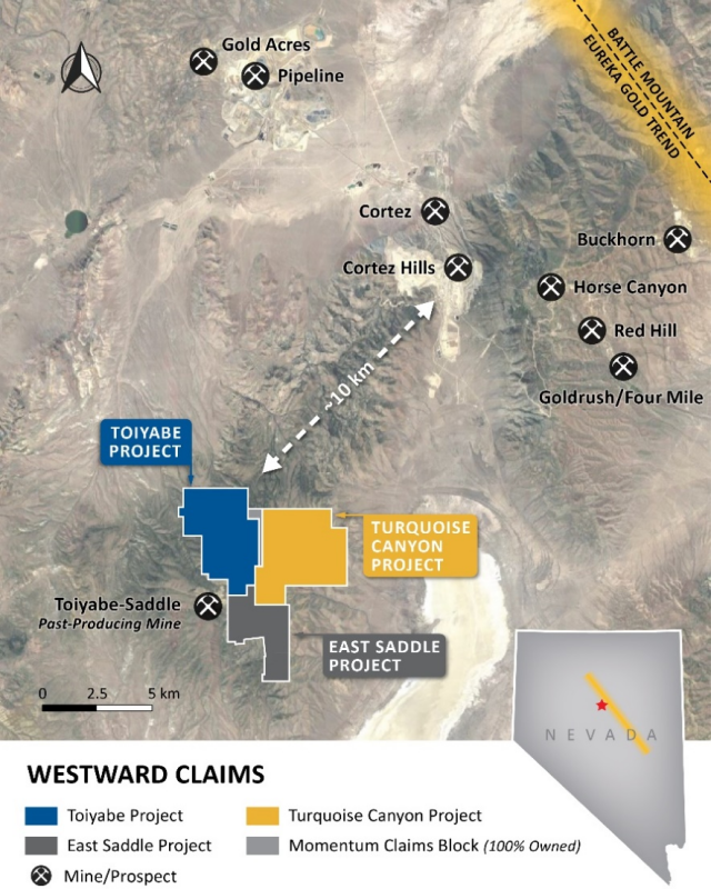
Figure 1: Westward’s Nevada Land Package (463 Claims / 3,830 Hectares)
Westward’s land package is situated along the Battle Mountain – Eureka Trend in Lander County, Nevada, and sits a short distance away from some of North America’s most significant producing gold mines and deposits. What began with the 165 unpatented mining claims covering the Toiyabe Project (“Toiyabe”) in April of 2021, has now grown to 463 claims (an increase of 181%) through a combination of corporate-level acquisitions and staking activities. The Company added the Turquoise Canyon Project (“Turquoise Canyon”) in July of 2021 and the East Saddle Project (“East Saddle”) in December of 2021.
Over the last year, the Company has significantly advanced its geological understanding of the land package; highlights of key programs are listed below with more in-depth technical details and figures in the paragraphs that follow:
Hyperspectral Core Imaging:
-
Summary: The Company completed hyperspectral imaging and analysis of ~15,000 meters of legacy drilling available in storage (3,050m of diamond core + 10,900m of reverse-circulation chips)
-
Key Takeaways: The observed alteration phases at Toiyabe are commonly associated with Carlin-type gold deposits in the area, and also coincide with gold mineralization on the property; alteration intensity provides a guide towards mineralizing structures, and will help inform future drilling
Airborne Hyperspectral Survey:
-
Summary: The Company conducted a high-resolution airborne hyperspectral survey with ~35km of coverage, including Turquoise Canyon, the historical resource at Toiyabe (~173 koz at 1.2 g Au/t)(1) (the “Historical Resource”), and surrounding areas
-
Key Takeaways: The survey identified common Carlin-type alteration minerals at surface, with SW-NE orientations that match known structures and gold-in-soil anomalies. Sub-surface alteration seen in drill holes at Toiyabe are also observed at surface on Turquoise Canyon (which has never been drilled), indicating the widespread extent of the system (~6.5km from Toiyabe-Saddle open pits to NE edge of Turquoise Canyon)
Induced Polarization Survey:
-
Summary: 17 line-kilometers of induced polarization (“IP”), primarily across undrilled Turquoise Canyon but also extending directly across the Historical Resource at Toiyabe
-
Key Takeaways: The main host rock at the Historical Resource (Devonian Wenban Formation) is interpreted to also be present at Turquoise Canyon, under only 150-250 meters of cover. The chargeability model confirms two near-term step-out targets at Toiyabe and further informs priority targets at Turquoise Canyon
Historical Drilling Compilation & Analysis:
-
Summary: A thorough review and compilation of previous drilling results across Toiyabe over the last ~30 years and multiple operators into a single comprehensive database, led by Steven R. Koehler (member of the Company’s Technical Advisory Committee)
-
Key Takeaways: Creation of a grade-thickness map, which confirmed the orientation of mineralization along the same trend as compressional features, and under-explored areas for follow-up. Identification of a major deformation zone beneath the Historical Resource at approximately 250m depth hosting widespread mineralization (25m+ intervals at +1 g Au/t(2); see below for additional details)
Field Mapping & Rock Chip Sampling:
-
Summary: Field work by the Company’s technical team resulted in the identification of a NE-SW trending fault, with jasperoid (decalcified and silicified limestone) exposed at surface along the trace of the structure
-
Key Takeaways: The newly-identified Toiyabe Hills Fault (“TH Fault”) is believed to be an extension of the 401 Fault – a documented control on gold mineralization at the Toiyabe-Saddle open pits. Rock chip sampling of the jasperoid confirmed anomalous gold and pathfinder elements, and led to the inclusion of this new target zone in the upcoming drilling campaign
Reinterpretation of Legacy Geophysical Data:
-
Summary: Reinterpretation of a 2008 gravity survey (based on a 200-meter sampling grid) – which had identified a significant gravity-high centered on the intersection of the Company’s 3 projects – using modern techniques; led by Jim Wright, a former Newmont geophysicist who specializes in Carlin-type systems
-
Key Takeaways: Confirmation of the IP findings related to the presence of favourable Lower Plate carbonates below the Upper Plate cover at Turquoise Canyon; refinement of near and medium-term drill targets; further understanding of the geometry of the carbonate window and associated structures at Toiyabe
New Stratigraphic Findings
-
Summary: The creation of stratigraphic columns for individual boreholes at Toiyabe, combined into cross sections for further analysis
-
Key Takeaways: Cross-section analysis provided for a new understanding of the role of compressional structures on stratigraphy, the dip of mineralization, and a potential link between mineralization at surface in the Toiyabe-Saddle open pits and at depth at Toiyabe. Repetition of favourable lithologies (stratigraphic duplex) appears to occur beneath the Historical Resource. Confirmed that gold mineralization is hosted in the Horse Canyon and Wenban Formations, which are documented gold hosts at the nearby Pipeline, Cortez Hills, Goldrush, and Fourmile deposits
(1) Source: NI 43-101 Technical Report, American Consolidated Minerals Corporation, Prepared by Paul D. Noland, P. Geo., May 27, 2009 (the “2009 Technical Report”). A qualified person has not done sufficient work to classify the historical estimate at Toiyabe (the “Historical Estimate”) as current mineral resources and Westward is not treating the Historical Estimate on Toiyabe as a current mineral resource, as defined in National Instrument 43-101 – Standards of Disclosure for Mineral Projects (“NI 43-101”). The Historical Estimate was calculated using mining industry standard practices for estimating Mineral Resource and Mineral Reserves (2005) which was prior to the implementation of the current CIM standards for mineral resource estimation (as defined by the CIM Definition Standard on Mineral Resources and Ore Reserves dated May 10, 2014). The key assumptions, parameters and methods used to prepare the Historical Estimate on Toiyabe are described in the 2009 Technical Report. While Westward considers the Historical Estimate on Toiyabe disclosed in this news release to be relevant to investors, it cautions readers that it should not be unduly relied upon in drawing inferences on the mineralization on Toiyabe, as additional work is required to upgrade or verify the Historical Estimate as a current mineral resource. This additional work includes (but may not be limited to): re-sampling and re-assaying of available core and/or pulps, verification of assay certificates and digital assay data, verification of select drill hole collars, review and verification of drill hole geologic logs versus the preserved core and RC cuttings, incorporation of AuCN assays to provide a general understanding of metallurgical characteristics, review and verification of mineralization controls and modelling techniques.
Additional Technical Details & Figures
Hyperspectral imaging, a powerful and modern tool used to identify individual minerals through their unique energy reflectance, has been a cornerstone of Westward’s pre-drilling activities. This has allowed the Company to glean new information from previous work, capitalizing on millions of dollars worth of past exploration under previous operators. At Toiyabe, this led to an objective dataset for ~15,000 meters of legacy drilling, which had until recently only been logged with the naked eye. Through this analysis, lithologies of the Lower Plate of the Roberts Mountains Allochthon were confirmed to host gold mineralization at Toiyabe, specifically the Horse Canyon and Wenban Formations. These rocks are documented gold hosts at the Pipeline, Cortez Hills, Goldrush and Fourmile deposits located ~10km to the north and east of Toiyabe. Silicification, decalcification, and argillic alteration – common alteration phases associated with Carlin-type deposits – are also present at Toiyabe and associated with mineralization. In addition, the alteration intensity (objectively measurable), provides a vector towards mineralizing structures and will inform future drilling. Alteration patterns, visible in the data, indicate that compressional structures and textures also play a key role in mineralization.
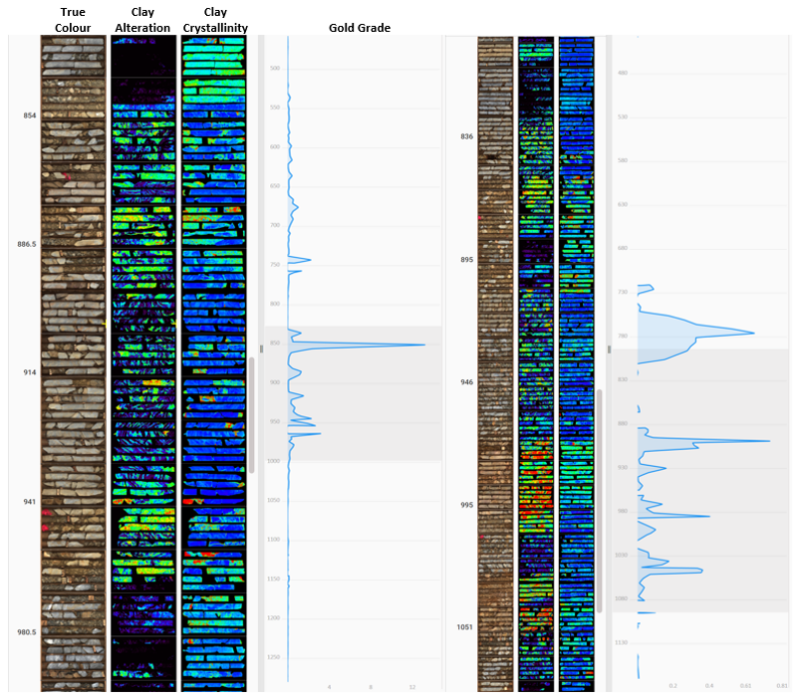
Figure 2: Hyperspectral Imaging – Drill holes T-1601 (Left) & T-1602 (Right)
Figure 2: T-1601 (left) and T-1602 (right) both intersected a major deformation zone at the same depth horizon, approximately 100 meters apart. The images above show a true-color image in the first column, clay alteration in the second column, and clay crystallinity in the third column. Both drill holes encounter intense clay alteration (second column, green and red colors). T-1601 demonstrates more highly-crystalline illite (blue in third column). T-1602 consists of mixed crystalline-illite and less-crystalline montmorillonite (blue and green in third column). The highly-crystalline illite is associated with a high-grade zone of 25.9m at 1.01 g Au/t(2). The objective measurement of clay crystallinity acts as a vector towards areas of higher mineralization and maps hydrothermal fluid flow.
Previous drilling only covered a very small portion of the Company’s overall land package, so in order to compliment the sub-surface hyperspectral data at Toiyabe, Westward conducted a regional airborne hyperspectral survey, covering Turquoise Canyon, Toiyabe, and surrounding areas. The 35km2 survey identified common Carlin-type alteration minerals, specifically illite, kaolinite, and quartz. The alteration occurs in NW-SE orientations that match known structures and gold-in-soil anomalies, and sub-surface drillhole alterations observed at Toiyabe are also present at surface at Turquoise Canyon, indicating a widespread system. Surface alteration patterns appear to repeat in succession from the Toiyabe-Saddle open pits (southwest) to the northeast corner of Turquoise Canyon, a span of approximately 6.5km.
Figure 3: Airborne Hyperspectral Survey (Alteration Minerals) + Soil Anomalies
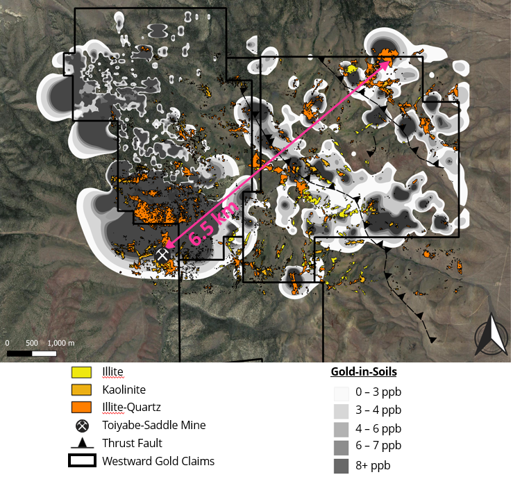
Figure 3: 35km2 airborne hyperspectral survey across the northern portion of Westward properties and surrounding areas (including the past-producing Toiyabe-Saddle open pits). Despite the presence of upper plate siliciclastic units at Turquoise Canyon, alteration commonly associated with Carlin-type deposits was present along major thrust faults and shear zones. The surface presence of Carlin-type alteration over a 6.5km strike length demonstrates the extent of the hydrothermal system. Furthermore, the presence of surface alteration along faults in the upper plate supports the theory of lower plate carbonate formations dipping onto the Turquoise Canyon project. The surface alteration includes clays such as illite, kaolinite, and illite-quartz mixtures, representing argillic and silicic alteration assemblages. In addition to following the NW-SE trace of mapped thrust faults, the alteration observed at surface is associated with gold in soil anomalies. The argillic and silicic alteration is also observed in drill samples at the Historical Resource and across the Toiyabe project.
The Company also undertook a 17-line-kilometer IP survey, which was primarily designed to refine targets at Turquoise Canyon where no previous drilling has taken place. One of the lines, however, extended 2km west of the property boundary and directly over the Historical Resource at Toiyabe, so as to compare the signature of known mineralization to the other 15km of potential targets. One of the key findings was that the Devonian Wenban – the primary host rock of the Historical Resource – is also interpreted to be present across Turquoise Canyon under Upper Plate cover approximately 150 to 250 meters deep. The resistivity model confirmed structures and fabric such as thrust faults and folds, and the chargeability model provided information related to the dip angle of structures which had been observed at surface – all contributing to more informed drill targets. Chargeability anomalies were observed that are associated with the Historical Resource and two step-out targets at Toiyabe (TH Fault and the California Zone), and also highlighted a potential feeder zone at depth to be tested in subsequent drilling.
Figure 4: 2021 IP Survey Location
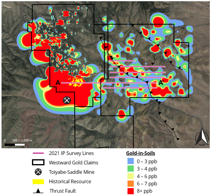
Figure 5: 2021 IP Survey – Line A-A’
Figure 5: Resistivity Inversion Model of the line marked A – A’. The interpretation was provided by Jim Wright of Wright Geophysics and highlights the presence of the Devonian Wenban Formation (Dw) as the main host rock of the Historical Resource, in green. The blue colors represent silica, interpreted as an alteration phase at Toiyabe and most likely as upper plate cover at Turquoise Canyon. The geometry of the Wenban formation as interpreted in the IP data demonstrates folding, a characteristic of a compressional structures, along with the upper plate Devonian Slave Formation (Dsl). Furthermore, the Wenban Formation is shown to have a shallow dip beneath the upper plate siliciclastics of Turquoise Canyon.
In addition to the drill samples that Westward has access to in storage, the Company has drill log data from 6 previous operators spanning approximately 30 years of exploration, which had not been consolidated and analyzed. This work was spearheaded by Steven R. Koehler, an exploration geologist with extensive experience along the Battle Mountain – Eureka Trend, and member of the Company’s Technical Advisory Committee. The focus of the analysis was to identify zones of mineralization which fell outside of the Historical Resource, identify patterns through the creation of a grade-thickness map, and feed assay data into a new 3D model interacting with all the other available datasets. Of note, a NE-SW trend of drill holes was found to have intercepted mineralization beneath the Historical Resource at approximately 250m depth. These holes revealed a major deformation zone hosting widespread mineralization, with intervals(2) such as 42.7m of 1.37 g Au/t, 33.8m of 1.16 g Au/t, and 25.9m of 1.01 g Au/t. These intervals occur at a similar depth horizon indicating continuity of the deformation zone, and the trend of successful intercepts is on-strike with the past-producing Toiyabe-Saddle open pit mines, suggesting the possibility that the mineralization is an extension of those deposits.
The legacy drill hole compilation also revealed areas of interest that were unexplored or under-explored. One of these areas is to the east of the Historical Resource, towards the boundary with Turquoise Canyon. Field work identified decalcified and silicified limestone (jasperoid) along the trace of a newly-identified fault (thereafter referred to as the TH Fault). The TH Fault is believed to be an extension of the 401 Fault which is a documented control on gold mineralization at the Toiyabe-Saddle open pit mines. Rock chip sampling of the jasperoid confirmed anomalous gold and pathfinder elements along the NE trend of the fault at both Toiyabe and Turquoise Canyon, with values including 31 ppb gold, 171.5 ppm arsenic and 234 ppb mercury.
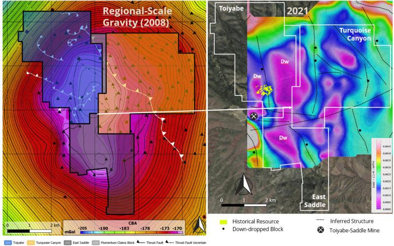
Westward also had access to a Complete Bouguer Anomaly (CBA) survey from 2008 (200-meter spaced gravity stations), which identified a significant gravity high straddling the boundary of Toiyabe and Turquoise Canyon, and contributed to the rationale for consolidating the two properties. The Company engaged Jim Wright of Wright Geophysics (former Newmont geophysicist) to reinterpret the data and produce residual gravity (RES) and horizontal gradient (HG) outputs. The RES image was produced by creating a smoothed regional grid which was then subtracted from the CBA to reveal more granular variations in measurements, while the HG image was created by measuring lateral variations in gravity measurements. Both images revealed a more detailed carbonate presence map and associated structures which may have been missed with the original CBA modeling. The RES and HG images confirmed the IP findings of Lower Plate carbonate rocks present below the Upper Plate at Turquoise Canyon, and also highlighted potential compressional features affecting the geometry of the carbonate window.
Figure 6: Reinterpretation of 2008 Gravity Survey
Figure 6: The image above displays the interpreted Horizontal Gradient (HG) image produced by Jim Wright using the CBA survey data from 2008. This HG image displays a series of horst and graben blocks gradually dipping to the east. The gravity data suggest these blocks are carbonate material interpreted as the Devonian Wenban Formation (Dw). The continuation of the Wenban to the east confirms the interpretation of the IP Resistivity model, which revealed compressional features and presence of the Devonian Wenban beneath the upper plate siliciclastic rocks at Turquoise Canyon. Several structures were also inferred from the HG image, supporting the current thesis of northeast trending structures and an overall dip of stratigraphy to the northeast. The northeast dip of mineralization will be tested in the upcoming 2022 drill program.
(2) Sources: NI 43-101 Technical Report, IM Exploration Inc., Prepared by Donald E. Cameron, P.Geo., August 5, 2021; Toiyabe data room and drill log files inherited from previous operators. The Company and its qualified person have relied on third-party data during its review of the information presented herein, and while it believes the information to be relevant to investors, it cautions readers that it should not be unduly relied upon in drawing inferences on the mineralization at Toiyabe, as additional work is required to confirm drill intercepts and/or soil samples, including (but not limited to): re-sampling and re-assaying of available core and/or pulps, verification of assay certificates where available, review and verification of drillhole geologic logs versus the preserved core and RC cuttings.
Corporate Update & RSU Grant
Westward and its permitting consultants have recently submitted a 2022 Work Plan (the “Work Plan”) to the Bureau of Land Management (“BLM”) which will govern its upcoming drill program at Toiyabe. Under the Company’s current Plan of Operations (“PoO”) – which includes a total of 100 acres of allowable surface disturbance – 10.1 acres are currently bonded under Phase 1 of the PoO. To date, previous operators have used a total of 4.6 acres under Phase 1, which includes access roads that the Company continues to benefit from. The Work Plan proposes an additional 4.1 acres of disturbance, with approximately 3,050 meters of new access roads and 15 new drill sites. Approval of the Work Plan is expected in the coming weeks, with earthwork activity to begin shortly thereafter. The Company’s fully-funded inaugural drill campaign, totalling approximately 4,000 meters over 12-15 holes, is on schedule to begin in June. Investors can expect further detailed updates in the lead-up to the program as important milestones are reached.
Westward is also pleased to announce that Dave Browning, VP Exploration, will be presenting at the upcoming Geological Society of Nevada (GSN) Symposium in Sparks, Nevada held from May 2nd-5th. The presentations will include overviews and analyses of each of the Company’s recent hyperspectral programs. Additional information about the event can be found at www.gsnsymposium.org.
The Company also announces that its Board of Directors has approved and granted a total of 2,500,000 restricted shares units (“RSUs”) to Westward management, Board of Directors, and consultants. These RSUs will vest over a period of 24 months, with 50% vesting on April 27, 2023, and the remaining 50% vesting on April 27, 2024. There are currently no other RSUs outstanding.
Qualified Person
The technical information contained in this news release was reviewed and approved by Steven R. Koehler, Technical Advisor to the Company, who is a Qualified Person under National Instrument 43-101 – Standards of Disclosure for Mineral Projects.
About Westward Gold
Westward Gold is a mineral exploration company focused on developing the Toiyabe, Turquoise Canyon, and East Saddle Projects located in the Cortez Hills area of Lander County, Nevada. From time to time, the Company may also evaluate the acquisition of other mineral exploration assets and opportunities.
For further information contact:
Colin Moore
President, CEO & Director
Westward Gold Inc.
colin@westwardgold.com
Tel: +1 (647) 403 0391
www.westwardgold.com
The Canadian Securities Exchange has neither approved nor disapproved the contents of this news release. The Canadian Securities Exchange does not accept responsibility for the adequacy or accuracy of this news release.
This news release contains or incorporates by reference “forward-looking statements” and “forward-looking information” as defined under applicable Canadian securities legislation. All statements, other than statements of historical fact, which address events, results, outcomes, or developments that the Company expects to occur are, or may be deemed, to be, forward-looking statements. Forward-looking statements are generally, but not always, identified by the use of forward-looking terminology such as "expect", "believe", "anticipate", "intend", "estimate”, “potential”, “on track”, “forecast", "budget", “target”, “outlook”, “continue”, “plan” or variations of such words and phrases and similar expressions or statements that certain actions, events or results “may”, “could”, “would”, “might” or “will” be taken, occur or be achieved or the negative connotation of such terms.
Such statements include, but may not be limited to, information as to strategy, plans or future financial or operating performance, such as the Company’s expansion plans, project timelines, expected drilling targets, expected BLM’s approval for the Work Plan and other statements that express management’s expectations or estimates of future plans and performance.
Forward-looking statements or information are subject to a variety of known and unknown risks, uncertainties and other factors that could cause actual events or results to differ from those reflected in the forward-looking statements or information, including, without limitation, approval from BLM will be obtained for the Work Plan, the need for additional capital by the Company through financings, and the risk that such funds may not be raised; the speculative nature of exploration and the stages of the Company’s properties; the effect of changes in commodity prices; regulatory risks that development of the Company’s material properties will not be acceptable for social, environmental or other reasons, availability of equipment (including drills) and personnel to carry out work programs, that each stage of work will be completed within expected time frames, that current geological models and interpretations prove correct, the results of ongoing work programs may lead to a change of exploration priorities, and the efforts and abilities of the senior management team. This list is not exhaustive of the factors that may affect any of the Company’s forward-looking statements or information. These and other factors may cause the Company to change its exploration and work programs, not proceed with work programs, or change the timing or order of planned work programs. Additional risk factors and details with respect to risk factors that may affect the Company’s ability to achieve the expectations set forth in the forward-looking statements contained in this news release are set out in the Company’s latest management discussion and analysis under “Risks and Uncertainties”, which is available under the Company’s SEDAR profile at www.sedar.com. Although the Company has attempted to identify important factors that could cause actual results to differ materially, there may be other factors that cause results not to be as anticipated, estimated, described or intended. Accordingly, readers should not place undue reliance on forward-looking statements or information. The Company’s forward-looking statements and information are based on the assumptions, beliefs, expectations, and opinions of management as of the date of this press release, and other than as required by applicable securities laws, the Company does not assume any obligation to update forward-looking statements and information if circumstances or management’s assumptions, beliefs, expectations or opinions should change, or changes in any other events affecting such statements or information.
